Dryness that lowered 2024 corn yields in the eastern Midwest is significantly less ahead of the start of fieldwork for 2025.

Dryness that lowered 2024 corn yields in the eastern Midwest is significantly less ahead of the start of fieldwork for 2025.

The weather pattern features multiple systems moving through the country during the next couple of weeks at least.

While wet season showers will ease up from east to west across central Brazil this week, it remains uncertain how much progress producers there can make from the slow start so far this season.

Corn Belt states are likely to end the December to February period with less than half their average snowfall.

La Nina is finally starting to kick in with a pattern change in early February.

Heat and dryness-affected production leads to a cut of more than half in Russia's wheat export supply to start 2025.

A weak La Nina is in place this winter, but it will not stick around long. What is expected for this spring and summer?

Slow-changing upper-air patterns tied to record-high world temperatures support winds driving catastrophic fires in the far West.

Some roller-coaster temperatures will occur this week, but we'll fall down the big hill this weekend after a cold front sweeps through the country.

Mountain snow water content in the Upper Missouri River basin is from one quarter to one third below average at the start of 2025.

After a big winter storm dropped 6 to 12 inches of snow and a band of freezing rain across the middle of the country this past weekend, another storm is set to bring more snow and freezing rain later this week.

A storm system will bring a band of heavy snow, a zone of freezing rain, and the potential for severe weather Jan. 4-6.

Hurricanes, heavy rain and drought sharply reduced the harvest of coffee, cocoa and oranges in 2024.

Forecasts predict a severe cold snap for early 2025 in areas east of the Rockies. A major storm system Jan. 4-6 will usher in arctic air, potentially breaking temperature records and disrupting travel.

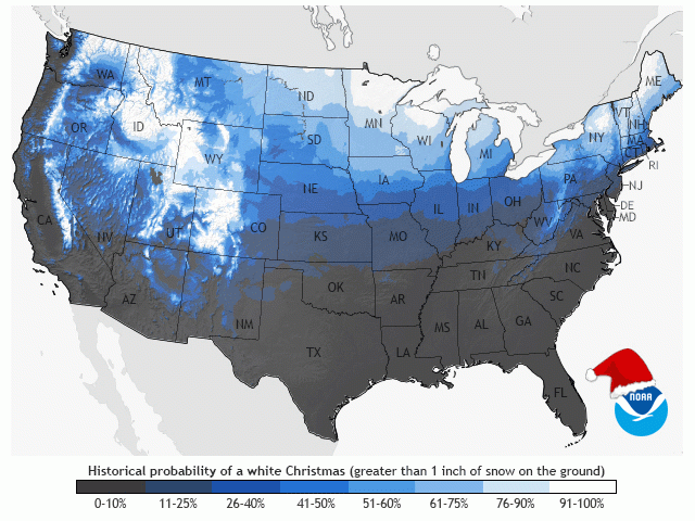
While it may seem like snow depths on Christmas have been trending down during the past few decades, that may not be entirely true.

There are signs that the atmosphere is changing, and a very cold pattern will set up across the U.S. and southern Canada for early to mid-January.

Lake-effect snowfall of 5-6 feet in late November to early December utilized record-warm conditions in most of the Great Lakes.

A clipper system will move from the Canadian Prairies through the northern U.S. Wednesday through Friday. The system will produce some heavy snow along its path and bring a burst of colder air.

Storm analysis finds climate change increased the wind speed for every hurricane in 2024.

A chaotic December pattern has led some to believe that the chances for a white Christmas are higher than average this year. Will that turn out to be true?
DIM[2x3] LBL[blogs-ag-weather-forum-list] SEL[[data-native-ad-target=articleList]] IDX[2] TMPL[news] T[]
DIM[2x3] LBL[blogs-ag-weather-forum-list-2] SEL[[data-native-ad-target=articleList]] IDX[5] TMPL[news] T[]