
Ag Weather Forum
What Are the Chances for a White Christmas This Year?
December 2024 has felt a lot more like winter than some of the last few years. We have seen a couple bursts of arctic air move in, the lake-effect snow machine has been running frequently and areas of snowfall accumulation have been occurring, especially in the Northeast.
This time of year, is particularly special for those of us who celebrate Christmas, as a blanket of white seems to bring a boost of holiday cheer to the season. It's no surprise that those of us with little or no snow cover as of Dec. 11 are looking at this pattern and thinking, are we going to have a white Christmas?
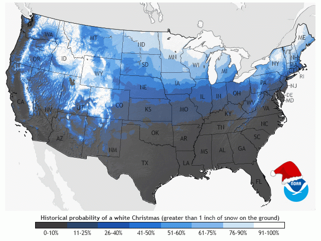
Climatologically, very few of us in the United States should expect a blanket of snow on Dec. 25. It's defined as an inch of snow on the ground early in the morning hours. A white Christmas has only a 50% or greater chance of occurring for those in the western mountains, in the interior Northeast, north of the line from northern South Dakota through north-central Iowa, and across central Michigan. Areas that are prone to lake-effect snow south of there are also favored to have a white Christmas, but for the rest of us, snow on Christmas morning is a relatively rare occurrence.
P[L1] D[0x0] M[300x250] OOP[F] ADUNIT[] T[]
Currently, the only areas that would qualify to have a white Christmas would be the peaks of the western mountains, the higher elevations of the Northeast, across northern North Dakota and Minnesota, as well as the lake-effect areas around the Great Lakes.
The forecast for next week is not all that favorable to prime us up in any meaningful way. Though the weather pattern stays chaotic, and several storm systems will likely move through, temperatures are forecast to be above normal for most of the country. That leads to more rain or melting if snow indeed falls. Even above-normal temperatures can produce snow across northern zones, and the climatologically favored areas are more likely to see this occurring.
There are some interesting features that could make for a big snowmaker during the week of Christmas, however. The upper-level pattern may be shifting enough to allow a ridge to develop over the West Coast. Much like we are seeing this week, that would allow for a burst of cold to move deeper through the eastern half of the country and allow for some widespread snow if it coincides with a bigger storm system -- but that is a big "if".
Medium-to-long-range model runs are not favoring this type of setup. Though a few models are, and the AI-driven forecast from the European ECMWF does show this setup.
It's tough to guarantee that a big storm system will bring a burst of snow to a wide area of the country. As long as the pattern stays active, there will be a chance that some of us south of the climatological average will see a joyful Christmas morning to play some Bing Crosby as the kids open their presents.
To find more weather conditions and your local forecast from DTN, head over to https://www.dtnpf.com/…
John Baranick can be reached at john.baranick@dtn.com
(c) Copyright 2024 DTN, LLC. All rights reserved.
Comments
To comment, please Log In or Join our Community .