

Ag Weather Forum
Weather Pattern Becoming More Active, Drought Relief for Corn Belt Uncertain
Heat and dryness have been issues lately across a lot of the Corn Belt. I mentioned yesterday that Thursday's Drought Monitor is likely to show increases in drought coverage and intensity across the Midwest and there is continued concern for young, developing crops in the region. You can find more details about the recent dryness in the Corn Belt here: https://www.dtnpf.com/….
The recent expansion of flash drought conditions has markets concerned as well. DTN Farm Business Editor Katie Dehlinger has more about that here in "Corn Market Rallies on Weather Fears," https://www.dtnpf.com/….
And the real concern is whether or not this pattern will continue. The pattern is concerning, but has more than enough time to turn around. There is a lot of season left. So far, the dryness has set a lot of the Corn Belt in a poor position early in the season and will need more than normal rainfall to get out of harm's way.
A persistent upper-level ridge of high pressure has dominated Canada for quite some time now, putting a lid on the jet stream and directing it northward. That has kept conditions rather stagnant for the last several weeks, focusing rain into the Plains states instead of the Corn Belt. However, that ridge is about to break down and open the door for disturbances to finally start pushing across more of the U.S. in the coming weeks.
P[L1] D[0x0] M[300x250] OOP[F] ADUNIT[] T[]
An upper-level trough is currently found in northern Canada and it is rounding the top of the ridge. It is forecast to dive down into the Great Lakes this weekend and shove the ridge to Western Canada where it will weaken and become less of a factor to the upper-air pattern. That will allow for disturbances that had been bottled up to get moving again. The first will be a front that moves through this weekend, bringing areas of scattered showers and thunderstorms to a lot of the country. These disturbances are forecast to frequently move through the U.S. over the following several weeks.
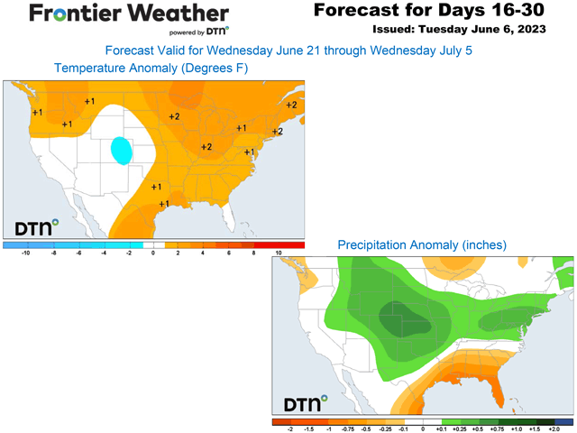
That should bring more fronts and systems through the middle of the country, increasing the chances for precipitation. In fact, DTN is forecasting this more active pattern to hold up through at least early July, leading to above-normal chances for the majority of the Corn Belt and Plains. Whether or not that will cause above-normal amounts is still to be determined.
Areas of drought are widespread, as noted in the above links. And even though the forecast is favorable, it does not mean that all areas will see relief. Active patterns produce areas of thunderstorms in the summertime, usually in clusters. Thunderstorms have a tendency to miss areas while bringing locally heavy rainfall to others. This produces winners and losers and there undoubtedly will be areas that do not get the rainfall that is forecast.
Another complicating factor will be in the upper levels again. A ridge is developing over Mexico and is forecast to sneak up into Texas next week, which may be a more persistent feature for the rest of June. Just how far north that expands will be important to building heat across the south and through the middle of the country, and how far south fronts and systems are allowed to sag through the country. The southwestern Plains, which has seen periods of heavy rainfall over the last few weeks, could be looking at drier conditions going forward. With the potential for more heat, that could expand drought back into areas that have seen some relief late this spring and that includes along the Gulf Coast.
And that heat may not be confined to the Southern Plains either. With a more active pattern, there will be some periods of heat that move through the rest of the country as well. The ridge over Texas will try to expand northward at times. These are more likely to be short-lived bursts, but could still produce stress in those areas that are not hit by rainfall adequately. The shifting ridge will likely change the trajectory of storm systems moving through the U.S., but timing will be key.
DTN Long-Range Weather Risk Analyst Nathan Hamblin is optimistic about some areas of Corn Belt getting some relief, but perhaps not all. "The weather pattern certainly favors more disturbances moving through the middle of the country, but where they occur is still uncertain. It's not like the flood gates will be opening up. This is likely to result in patches of relief rather than wholesale improvement of the drought that is building in the Midwest. Southern areas (like Kansas, Missouri, and Kentucky) are favored at the moment."
It's summertime and anything can happen with thunderstorms. Drought relief is likely to come, but whether or not that will mean across the bulk of the Corn Belt or just parts remain to be seen. Drought will continue to be a factor throughout the rest of the season.
To find more weather conditions and your local forecast from DTN, head over to https://www.dtnpf.com/…
John Baranick can be reached at john.baranick@dtn.com
(c) Copyright 2023 DTN, LLC. All rights reserved.

Comments
To comment, please Log In or Join our Community .