Ag Weather Forum
Dryness and Drought Increasing Across the Midwest
Farmers and ranchers have been nervous about it for the last several weeks and the Drought Monitor confirmed it last week -- it has been abnormally dry across the Midwest for some time now. It's a pattern that needs to reverse itself before we get too deep into the season to fulfill the forecast for trendline yields and high production of this year's crop. The USDA will put out its World Agricultural Supply and Demand Estimates (WASDE) on Friday, and DTN will have coverage of that event later this week. Join us Friday at 11 a.m. CDT for coverage of the June WASDE report. At 12:30 p.m., DTN Lead Analyst Todd Hultman will review details of the report in his monthly webinar. You can sign up for that webinar here: https://www.dtn.com/… and also keep an eye out later this week for DTN's reports preview and post-report coverage and analysis.
USDA is unlikely to change its position on the crop this early in the season.
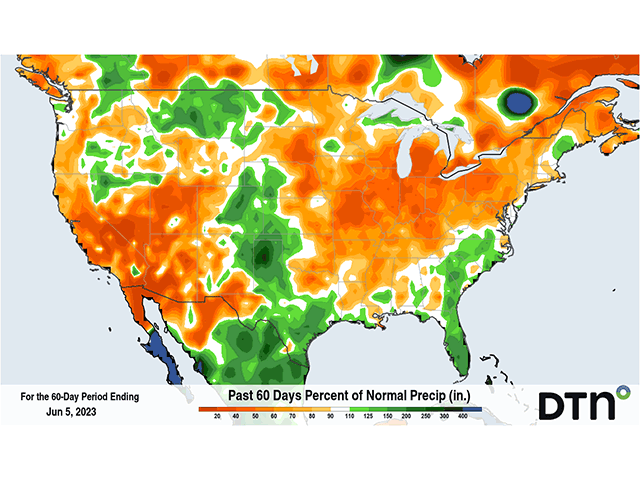
But that won't stop producers and traders from taking the growing dryness situation seriously. During the last two months, precipitation has largely been below normal across the entirety of the Corn Belt. A stagnant weather pattern is mostly to blame in that regard. That has featured a ridge of high pressure across central Canada, blocking the upper-level pattern from allowing many or any disturbances to move across the U.S. Instead, weaknesses across the Southwest and Southeast U.S. have led to enough energy to produce scattered showers and heavy rainfall for parts of the West, Plains, and Southeast.
But it has kept the Midwest almost completely dry. At times, isolated showers have moved through, but it has been a pretty quiet weather pattern for the highest-producing areas of corn and soybeans in the country. This is almost a complete reversal in the La Nina pattern that affected the U.S. during the last two years, where it was extremely hot and dry west of the Mississippi River and wet to the east.
P[L1] D[0x0] M[300x250] OOP[F] ADUNIT[] T[]
In April, the pattern was not much of a concern because it allowed planting to progress nicely, culminating in a faster than normal planting pace for most of the country outside of North Dakota, which finally caught up in late May. Most of the country's corn, soybean, and spring wheat acres are planted, with only small pockets left to go. However, with the onset of summer and increasing temperatures, and readings eclipsing the 90-degree Fahrenheit mark since last week, drought stress is becoming more of a serious concern.
Soil moisture has been declining during the last two months for most areas, especially in the Eastern Corn Belt, and flash drought is occurring. Flash drought is described as a rapid onset of drought, and typically the effects are felt before it is classified as drought. As many are reporting on Twitter in states such as Illinois and Indiana, corn leaves are curling in the afternoon and crop ratings from the USDA are falling. Illinois' good-to-excellent rating for corn fell 19 points, Indiana and Wisconsin each fell 10 points, while Michigan fell 20 points and Ohio fell 17 points. The only states to see increases in the crop condition on corn were in the Plains where rains have been prevalent. North Dakota, Nebraska, and Colorado saw modest increases. Soybean conditions were only first released this week so we cannot compare to last week.
For more specific information about Illinois, check out Bryce Anderson's blog here: https://www.dtnpf.com/….
The drought monitor that will be released on June 8 will undoubtedly increase the areas of dryness and drought across the Corn Belt with the lack of rain and increased heat over the last week. Some areas in the western half of the Corn Belt have been seeing some rainfall, however. But those have been little isolated showers.
Those lucky enough to be hit by a shower have seen some heavier rainfall. Anecdotal reports of a farm getting an inch or 2 contrast with their neighbors that see nary a drop. The Drought Monitor is not able to carve out such small areas and thus will generally maintain drought categories where those showers have hit, and expand drought where they miss.
Thursday's update will be very important to find the extent that drought covers the Corn Belt, and DTN will provide coverage on that over the next few days, but it is still early in the season. A change in the pattern and a return to a more active series of systems that move through the country could quickly rebuild soil moisture and get America's Heartland back on track for the growing season.
I will have another story tomorrow about the coming change in the pattern and whether or not that can be counted on for turning around the drought situation. Stay tuned to DTN for the latest on the growing concerns.
If you missed it, see DTN's recent story on the "Five Signs of Early-Season Drought Stress" at https://www.dtnpf.com/….
To find more weather conditions and your local forecast from DTN, head over to https://www.dtnpf.com/…
John Baranick can be reached at john.baranick@dtn.com
(c) Copyright 2023 DTN, LLC. All rights reserved.


Comments
To comment, please Log In or Join our Community .