

Ag Weather Forum
A Long Line of Weather Systems Moving Forward for Canadian Prairies

It has been a rather stagnant weather pattern across the Canadian Prairies during the last week. Temperatures have been quite high, especially in the eastern half of the region, with daily highs reaching or exceeding 30 Celsius (86 Fahrenheit). At the same time, areas of isolated to scattered showers have been falling across a wide area of the region.
Saskatchewan has benefited the most from the pattern, with widespread reports over 25 millimeters (1 inch) during the last week, and several spots over 50 mm (2 inches), especially in eastern areas of the province.
Manitoba has seen some similar conditions as well, though maybe not as widespread with the rainfall and a bit hotter overall that may have been producing some stress. Precipitation came with scattered showers though, and have missed some areas of both provinces, but most areas saw good conditions over the last week.
That was noted in both provinces' crop reports that came out this week. In general, crop and pasture conditions have improved in both during the last week, though there are lingering trouble spots. Drought conditions have not updated just yet. We will check on that next week.
P[L1] D[0x0] M[300x250] OOP[F] ADUNIT[] T[]
Alberta has not had nearly the rainfall that the other two provinces have enjoyed. Though some spotty rains have occurred in some areas across the east and north, many of the central and western areas of the province did not see a drop in the week ending June 8.
But the weather pattern is changing. A front went through the region June 8 and dipped into the Northern U.S. Plains, but the western end of that front is stuck near the Rockies in southern Alberta, which is producing some heavier rainfall near the border on the morning of June 9. This area looks to stay active through the weekend and some isolated showers may develop over other parts of the province as well.
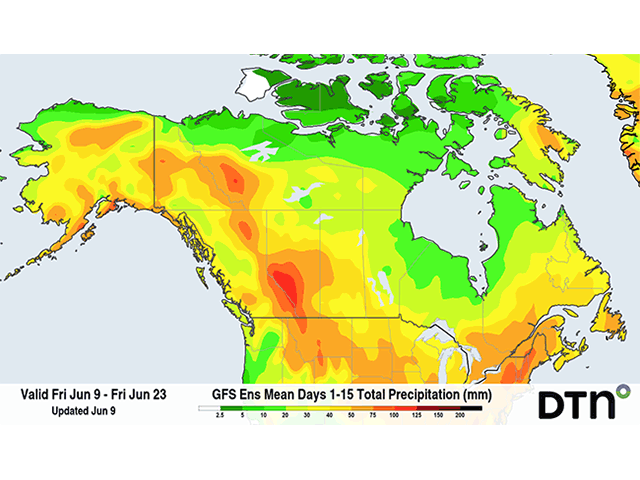
While the daily showers and thunderstorms that have dotted the Prairies during the last couple of weeks is coming to an end, the pattern will favor more systems moving through the region going forward.
One such system may not generate much precipitation June 12-13, but another June 13-15 is forecast to produce more widespread precipitation across the region, including in drier Alberta. That system should bring cooler conditions to the region as well, though frosts are not expected at this time.
Additional systems are forecast to move through the region thereafter, though the details of the systems are still being worked out by models. Still, the region is in a position to see more widespread rainfall going into late June and potentially into July as well. Showers may be scattered and not all areas are going to be hit equally of course, but most areas should end up with favorable rainfall during the next couple of weeks at least.
Temperatures are likely to waffle around climate normals for the rest of the month as systems pass by as well.
To find more international weather conditions and your local forecast from DTN, head over to https://www.dtnpf.com/…
John Baranick can be reached at john.baranick@dtn.com
(c) Copyright 2023 DTN, LLC. All rights reserved.
Comments
To comment, please Log In or Join our Community .