
South America Calling
Is End of Wet Season Coming Early for Central Brazil?
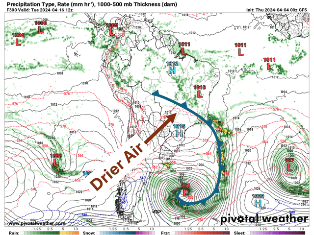
As I mentioned last week here https://www.dtnpf.com/…, subsoil moisture in central Brazil is not up to par and there isn't a lot of time before the wet season rains begin shutting down. Rains typically start to gradually decline in April and shut off and move north in May. However, we may see a more abrupt shift to drier weather if a storm system can develop as forecast around the middle of the month.
Before that storm system arrives, it will be an active period across most of South America. Several fronts will be moving up from Argentina and through southern and central Brazil, bringing a 10- to 12-day stretch of continued wet weather for a lot of the continent. Heavy rain is likely limited as the fronts are moving and not stuck in any one area for a significant length of time. So, in general, it's a good period of rain, but not one of soaking, heavy rain that would be building subsoil moisture for too many locations.
P[L1] D[0x0] M[300x250] OOP[F] ADUNIT[] T[]
By late next week or weekend, around April 13, one of these fronts is forecast to turn into a very strong storm system. The GFS model has been somewhat consistent on this system being the last in a line of systems to move through. Behind the cold front to that system, Argentina, Paraguay and southern Brazil all dry out rather substantially. The GFS is also suggesting the front may be strong enough to push north through central Brazil and into northern Brazil, north of Mato Grosso, Goias and Minas Gerais. This will be key concerning further moisture for the fall season of safrinha corn. If that front clears through these central states, the period of active wet weather will largely be over. The wet season has an average end date of about May 5 in these areas. And if it stays dry for a week after April 15, that will likely mark the end of the traditional wet season rainfall.
The GFS model cannot be completely trusted two weeks out, of course, but we have seen this trend in the longer-range versions of both the GFS and European models for some time. We just have not seen the mechanism by which these models were showing the end of the wet season. This front will likely do it. Argentina and southern Brazil are forecast by these longer-range models to get some moisture back in at the end of April and early May, but that is typical for these areas during the fall season. What they do not show is a return of any moisture back up into central Brazil.
The safrinha corn crop was largely planted on time this season, despite some late planting and replanting of soybeans this past spring due to an extended dry period. In the state of Parana, only 33% of the crop has reached pollination. Farther north, where planting was a bit further behind, that number is likely to be lower. In other words, there is a substantial portion of the crop that will be vulnerable to the end of these showers if it indeed occurs behind that front in the next 10 days. With subsoil moisture lacking, this early end to the wet season would be harmful to the safrinha corn production in Brazil. States like Mato Grosso do Sul, Parana and Sao Paulo, which have not had wet season rains like those farther north, will be more at risk, though they could benefit from fronts still moving north from Argentina into May.
To find more international weather conditions and your local forecast from DTN, visit https://www.dtnpf.com/….
John Baranick can be reached at john.baranick@dtn.com.
(c) Copyright 2024 DTN, LLC. All rights reserved.

Comments
To comment, please Log In or Join our Community .