South America Calling
Watching Safrinha Corn in Brazil with Wet Season Essentially Over
Two weeks ago, I suggested that the wet season showers in central Brazil looked like they were going to be consistent for a while, but ended early as a front went through this week. It looks like that forecast has turned out to be mostly true. You can read more about that forecast here: https://www.dtnpf.com/….
Since that time, the rain that has fallen has been significant and more than forecast for large areas of the western and southern safrinha (second-crop) areas. Estimates of more than 100 millimeters (about 4 inches) are pretty common from Mato Grosso down to Rio Grande do Sul. Rainfall has not been as kind to those in portions of Sao Paulo or Minas Gerais, which have been very dry during the last couple of weeks and less than 25 mm (about 1 inch) has fallen in that time. So not all areas have been blessed with good rainfall to end the wet season.
P[L1] D[0x0] M[300x250] OOP[F] ADUNIT[] T[]
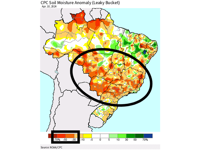
Now that those wet season rains are coming to an end, the safrinha corn crop in central and southern Brazil will be more dependent upon the built-up subsoil moisture and fronts coming from Argentina. Unfortunately, the most recent satellite estimates still paint the region with below-normal soil moisture in most cases. A data outage from NOAA has limited the most recent images to April 10. But at the time, almost all areas of Brazil's safrinha corn growing areas had soil moisture profiles that were behind by 30-50%. Some pockets in southern Goias and Mato Grosso were not as dry, but still below normal.
Fronts coming up from Argentina will still capture some decent rainfall for southern states like Parana and Mato Grosso do Sul. In fact, a front moving through early next week is likely to stall in the region and produce several days-worth of showers and thunderstorms. Totals are forecast in the 25- to 50-mm range (1- to 2-inch range) and will help to sustain the crop.
Those fronts may be active in May as well, which would provide some benefit if they can make it up into the southern portions of the region, but areas farther north are unlikely to see much rain from now on. Any showers in central Brazil now would be isolated and more likely closer to the Amazon. That could help some areas of Mato Grosso, but the amounts likely will not make up for days in the 30s Celsius (upper-80s to upper-90s Fahrenheit).
In total, this paints a poor picture for the safrinha corn that is entering or in its pollination period and heading into filling. The crop was largely planted on time and the early planted corn crop will do much better than the later-planted crop. But as the season wears on, during the next four to six weeks, crop conditions will be monitored closely and are likely to fall.
To find more international weather conditions and your local forecast from DTN, visit https://www.dtnpf.com/….
John Baranick can be reached at john.baranick@dtn.com
(c) Copyright 2024 DTN, LLC. All rights reserved.


Comments
To comment, please Log In or Join our Community .