
South America Calling
Central Brazil's Subsoil Moisture Still Looks Bad
Subsoil moisture continues to be the talk of the safrinha (second-season) corn crop for central Brazil. The lack of a significant pool of reserves continues to threaten the corn crop when rains shut down in late April or early May.
There have been thoughts that recent heavy rainfall due to a stalled front in the region from Mato Grosso to Minas Gerais since March 22 would provide some much-needed rainfall to build subsoil moisture. And although those rains have fallen and been quite good in some areas, it has barely moved the needle on subsoil moisture.
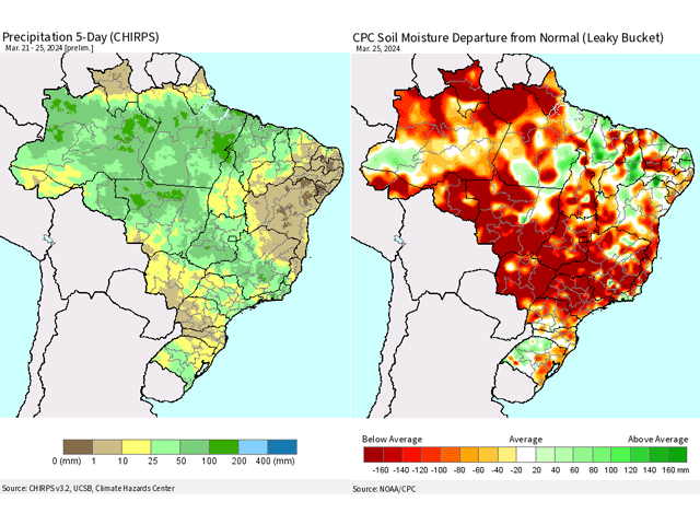
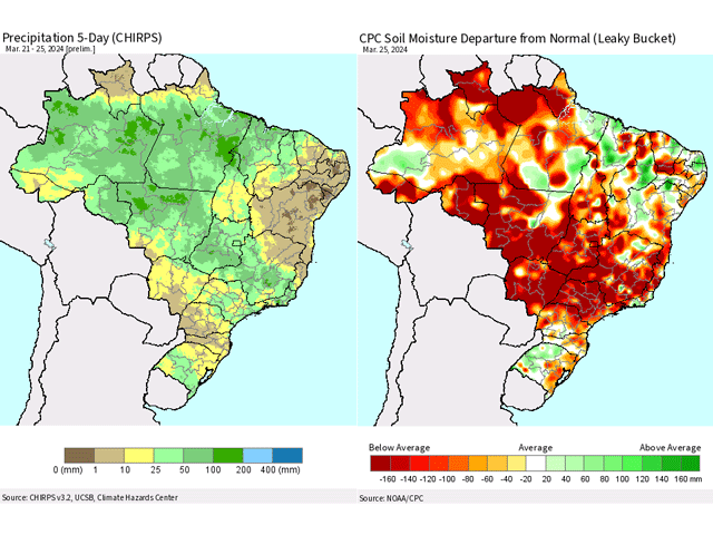
In the most recent satellite observations valid on March 25, soil moisture is still more than 150 millimeters (about 6 inches) below normal for most of the safrinha corn-growing areas of Brazil. That comes despite more than 50 mm (about 2 inches) in most of the region in the five days leading up to that. You can see the comparison in the image attached to this blog. True, this does not account for the rainfall during the last two days, but still speaks to the significant deficits that are in place.
P[L1] D[0x0] M[300x250] OOP[F] ADUNIT[] T[]
Looking at topsoil moisture, we see a much-improved column in most of these areas. However, it has not been enough to increase subsoil moisture. Crops are using up this moisture quickly and it is not making it into the subsoils.
Southern areas of the main safrinha corn growing region, in southern Mato Grosso do Sul and Parana, have had relatively little, with less than 10 mm in that same timeframe. These southern areas are also experiencing very low subsoil moisture and are at even more of a risk of dryness than areas farther north.
It has been raining since and will continue to rain from Mato Grosso to Minas Gerais through this weekend and into next week. Models may be overproducing coverage and intensity, but another 50-100 mm looks likely from Mato Grosso to Minas Gerais and points northward between March 28-April 3. Another 50-100 mm is forecast for the week after that as well. Based on the previous five-day period, that amount likely will not move the needle much either, though it will not hurt.
Depending on which model and run you look at, wet-season rainfall could shut down in mid-April, a couple of weeks ahead of normal and as corn enters its critical pollination period.
Producers in Brazil count on sustained rainfall through pollination and then rely upon subsoil moisture to fill out the rest of the corn crop. If rains end early and/or subsoil moisture is limited, that could produce significant reductions in corn production out of the country. Even though the rain has been good recently, and looks like it may continue for the next week or two, deficits have been so large during this season that the crop may end up suffering anyway. We should be paying very close attention to these satellite estimates for soil moisture during the next couple of weeks, our best evidence of the reserved water for the filling corn crop. The crop may look good now, while it is still raining, but it may not last long when the rain end.
To find more international weather conditions and your local forecast from DTN, visit https://www.dtnpf.com/….
John Baranick can be reached at john.baranick@dtn.com.
(c) Copyright 2024 DTN, LLC. All rights reserved.
Comments
To comment, please Log In or Join our Community .