South America Calling
Argentina's Crops Improving, But February Forecast Not Favorable

Yet another round of good rain fell on Argentina late last week. Both corn and soybeans showed improvements on the weekly crop progress report from the Buenos Aires Grain Exchange. For the case of corn, good ratings increased 10 points to 22% while poor ratings fell 7 points to 32%. The numbers were not as beneficial for soybeans, but improvements were still made with an increase in the good rating of 5 points to 12%, and a fall of poor ratings by 8 points to 46%. Both of these crops are still in worse shape than at the same point last year, a year which saw production fall from the previous year. This crop remains on track for lower production numbers, as suggested by recent forecasts from both private and public sources.
But most crops are well into their reproductive stages of growth. Corn is a little trickier, as the total planted acreage is down due to the early drought, and the fact that it is planted in two stages. For corn, 55% of the first-phase crop is tasseling. It is 35% of the second-phase crop. Additional water at this point does not add to yield potential, but can keep it from getting worse. It will also help to fill grain of course. The second phase has more potential to add to yields. For soybeans, 48% are blooming while 21% are setting pods. The rains came at the right time, but as we know up here in North America, August is the time rain is needed the most to fill pods. The equivalent month in Argentina is February, though that is extended into March as well. Rains during this month will be counted on for the soybean crop especially, but also for a large portion of the second-phase corn crop.
P[L1] D[0x0] M[300x250] OOP[F] ADUNIT[] T[]
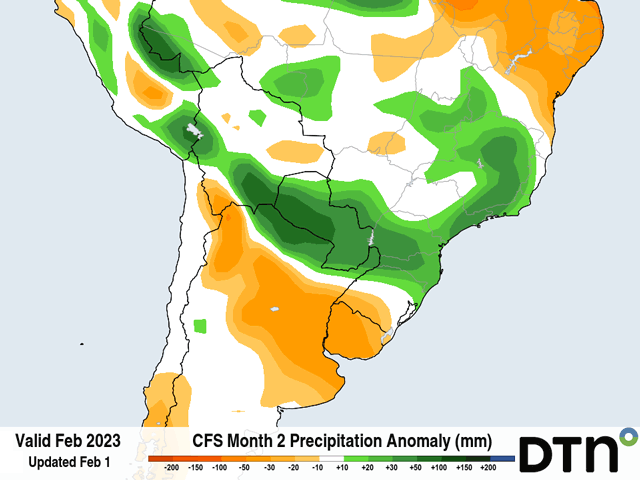
However, looking at the forecast for February does not offer hope that the recent boost to crop health can be sustained. During the next 10 days, there is a very limited chance at producing some isolated showers in the main Pampas growing region in the middle of the country. The eastern portions of the region could find a few spotty showers early next week, or next weekend, but much of the region will remain dry. At the same time, temperatures will rise well-above normal again. While the region is usually very warm to start with, temperatures above 35 Celsius (95 Fahrenheit) are going to be more common again, especially to the west and away from the Atlantic. The soil moisture improvements that the region saw with the few events during the last two weeks are going to be used up quite quickly.
Even the rains that come later in the month may not be overly helpful. Longer-range models are pointing to another cold front or two that could produce some decent rainfall in the region around mid-month, between Feb. 12-16. Predicting rainfall amounts at that range is somewhat of a dubious task, but even then, it could amount to another round of 25 to 50 millimeters (about 1 to 2 inches). The region would then go through another dry period before rains return at the end of the month, possibly in the same range. For most of the region, monthly rainfall is around 100 to 130 mm (about 4 to 5 inches). Predicted rainfall amounts for the month are therefore near or below normal. With soil moisture only slightly improved during the last two weeks and no significant improvements upcoming during this important month, it is hard to imagine that the slight turnaround we have seen in corn and soybeans for Argentina will continue that trend for the next several weeks. At that point, rains that come later in March and April will be too late for either phase of corn and most of the soybean crop. Only the latest-planted soybeans would see any benefit. But even now, the seasonal forecasts for March and April are for above-normal temperatures and below-normal rainfall.
To find more international weather conditions and your local forecast from DTN, visit https://www.dtnpf.com/….
John Baranick can be reached at john.baranick@dtn.com
(c) Copyright 2023 DTN, LLC. All rights reserved.


Comments
To comment, please Log In or Join our Community .