South America Calling
Crop Conditions Improve in Argentina, Concerns Linger
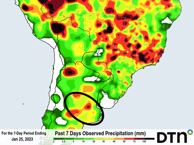
A good round of rain along a cold front moved through Argentina's Pampas region, the primary corn and soybean growing region Jan. 20-21. A widespread swath of 20 to 40 millimeters (0.78 to 1.57 inches) fell over some of the most drought-stricken areas of the country and there were some locations that saw over 50 mm (1.97 inches).
In response, crop conditions improved for both corn and soybeans according to the Buenos Aires Grain Exchange in its report released Jan. 26.
Good ratings on corn rose from 5% last week to 12% this week. For soybeans, good ratings rose from 3% last week to 7% this week. Also important was a drop in poor ratings. For corn, poor ratings fell from 47% last week to 39% this week. For soybeans, the drop was from 60% to 54%. Conditions improved more for corn than for soybeans, which was somewhat surprising given how advanced early planted corn has become.
P[L1] D[0x0] M[300x250] OOP[F] ADUNIT[] T[]
Obviously, these ratings are still really poor, but the note should be made that since ratings improved, further rainfall events would likely help the case as well. For producers down in Argentina, though, this week has not lived up to expectations just yet.
Some isolated showers have been falling in the Pampas this week as a frontal boundary has moved into the region, but have been spotty and mostly light. Rainfall amounts have generally been less than 15 mm (0.59 inches) with only a few spotty exceptions. Forecasts from last week pegged the region to receive widespread amounts of 30 mm (1.18 inches) through Jan. 26.
There are still additional chances for precipitation in the Pampas with another boundary moving through Jan. 26-27, but the chances increase farther north for the weekend, over less dense agricultural lands. Still, models are indicating good rainfall chances and coverage as the front passes through, with amounts roughly another 10-25 mm (0.39 to 0.98 inches). The showers are scattered though, and may not meet that 10-mm threshold in all areas, which would be disappointing given last week's forecast.
Rain has been hard to come by on a consistent basis and that continues to be the concern for the crop moving forward. With a lot of the corn and soybeans entering their reproductive stages of growth, the rains during the next month are very important. Another front will move through around the middle of next week with a chance for showers as the calendar flips into February. Long-range models of both the American GFS and European models are indicating somewhat better chances for rain around mid-February and again late-February. But a chance every two weeks would not equate to good rainfall for an ailing crop.
These dryness concerns extend into the southern states of Brazil as well, where crop conditions have reportedly been falling after disappointing rainfall amounts for weeks. Dryness over Argentina and southern Brazil are a common feature of La Nina. And although temperatures in the tropical Pacific Ocean are increasing toward normal, the effect on the atmosphere takes some time to work itself out. The rest of the growing season's weather pattern does not favor good crop production in either location.
To find more international weather conditions and your local forecast from DTN, visit https://www.dtnpf.com/….
John Baranick can be reached at john.baranick@dtn.com
(c) Copyright 2023 DTN, LLC. All rights reserved.


Comments
To comment, please Log In or Join our Community .