

Ag Weather Forum
Driest Western Corn Belt in a Lifetime
For some large portions of the Western Corn Belt, the four-year period from December 2019 through November 2023 has been the driest in a lifetime. That's the takeaway from a review of 48-month precipitation totals posted on the NOAA National Centers for Environmental Information (NCEI) Climate at a Glance website.
That stark assessment is certainly true in Iowa. The 48-month Iowa statewide precipitation total calculated by NCEI is 113.72 inches. That is 27.52 inches below the 1991-2020 mean precipitation value of 141.24 inches. It's also the eighth-driest four-year stretch in a total of 125 four-year periods on record going back to 1895.
The driest such period on record was back in December 1954 to November 1958 -- 65 to almost 70 years ago. Other periods in the 1950s ranked second-, sixth- and seventh-driest. The 1930s periods of December 1932 to November 1936 and December 1933 to November 1937 rank third- and fifth-driest. The fourth-driest such period was from December 1909 to November 1913. The 1930s also had the ninth- and 10th-driest periods, December 1935 to November 1939, and December 1929 to November 1933.
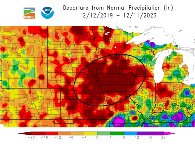
Along with Iowa, major precipitation deficits are widespread across the Western Corn Belt. Graphics displaying precipitation totals relative to normal show large blocks of deep red from eastern Kansas and eastern Nebraska eastward to southwestern Wisconsin; this includes close to the entirety of Iowa.
P[L1] D[0x0] M[300x250] OOP[F] ADUNIT[] T[]
The color scale depiction on such graphics indicates more than 20 inches of precipitation below normal. But color scales do not do the specific precipitation deficits justice. Weather station data catalogued by Iowa State Climatologist Justin Glisan show four-year precipitation deficits of close to 50 inches below normal in some locations. In eastern Nebraska, reports gathered by University of Nebraska-Lincoln Extension Climatologist Eric Hunt show deficits of 30 or more inches compared with normal amounts.
National Drought Mitigation Center Climatologist Brian Fuchs has been tracking this developing drought going back to the fall season in 2019. "After having the historical flooding in the region in the spring of 2019, we went into drought development in the fall of 2019 and that dryness has been building ever since," Fuchs told DTN. "For the most part, much of the deficit can be attributed to a lack of recharge to the soils in the fall and into winter before the ground freezes up and that immediately impacts the next growing season due to the lack of the 'banked' moisture in the soil profile."
Dryness is now at the point where stream flow in waterways along with community water supplies are notably declining. "The impacts are starting to include more of the long-term hydrological concerns such as surface and groundwater, as well as individual wells," Fuchs said. "As I tell people, normal moisture would go a long way to helping ease the drought, but it will take consistent above-normal moisture for quite a while to improve upon all the damage that has been done over the past four-plus years."
However, for the balance of this winter, consistent above-normal moisture has a low probability of occurring in the Western Corn Belt, with a strong influence from the current El Nino Pacific Ocean temperature pattern, USDA Midwest Climate Hub Director Dennis Todey told a recent NOAA regional forecast webinar. "This is something that people should be monitoring and working with and looking ahead to if we should continue our situation," Todey said. "Because we don't expect with the El Nino that there would be widespread major precipitation that would fix the situation."
Both public and private forecasts call for storm tracks associated with El Nino to track to either the north or south of the Western Corn Belt through the balance of the winter season. That means that the lifetime-level life of the extended Western Corn Belt drought is likely to remain prominent as we look to the start of 2024.
More details on El Nino's effect on winter precipitation are available here: "El Nino Brings Winter Moisture Concern to Midwest," https://www.dtnpf.com/….
Information on drought and its effect on hay supplies going into this winter is available here: "Cattle Producers in Drought Areas Weighed Down by Winter Feed Worries," https://www.dtnpf.com/…
Prospects for Christmas holiday snow are available here: "Chances for a White Christmas?" https://www.dtnpf.com/…
Bryce Anderson can be reached at Bryce.Anderson@dtn.com
(c) Copyright 2023 DTN, LLC. All rights reserved.

Comments
To comment, please Log In or Join our Community .