

Ag Weather Forum
Christmas Storm Uncertainty: Trying to Make Sense of How, When and Where Multiple, Widespread Impacts Will Hit

Last week in this space I wrote it was not out of the realm of possibility to see a storm system moving through that could give some folks a chance to see a white Christmas morning, but it was unlikely at the time. You can read a little about that here: https://www.dtnpf.com/….
The chance for a white Christmas is still pretty low, but not for some folks in the Plains. And other areas will deal with additional hazards from a storm system that now is expected to pinwheel slowly through the country this weekend going through the week of Christmas.
Snow may only be a hazard for a select few areas, but heavy rain, strong winds, and severe weather will all be on the table. However, there is a lot of uncertainty with this system that needs to be discussed.
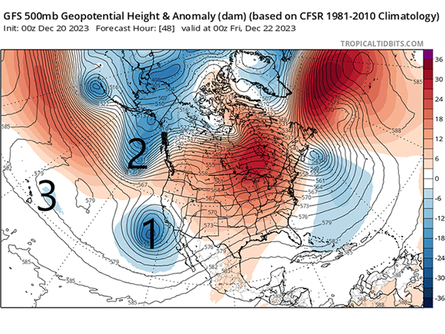
First let's describe the setup for the storm. A cutoff low-pressure system is sitting off the coast of California on Dec. 20. That system will drift eastward into the Southwest on Dec. 22-23 and will spark some developing showers in the Central and Southern Plains going into Dec. 24.
At the same time, another piece of energy coming from a trough over Alaska will move into the West and the two will have some sort of interaction, likely deepening a storm system over the Plains and Midwest for Dec. 24-25.
Yet another piece of energy that is currently out by Hawaii will follow into the new trough Dec. 25-26, continuing the storm into the East Coast.
All three pieces of energy will interact with each other, which will keep the storm going and spread a bunch of precipitation near and east of the Rockies not only this weekend but also through much of next week.
P[L1] D[0x0] M[300x250] OOP[F] ADUNIT[] T[]
Conditions have been awfully warm for most of the country during the month of December. An upper-level ridge has been rather dominant over Canada the last couple of weeks and the cold, polar air mass has instead been located in Russia on the other side of the North Pole.
A strong Pacific jet stream has instead flooded most of North America with milder air. Occasionally we have seen some breaks in that, but the warmth has certainly won out this month. That continues through this weekend and next week as well, meaning the storm system to come does not have access to a lot of cold air to build widespread heavy snow.
In fact, many areas in the Upper Midwest are looking at breaking temperature records for Saturday, Sunday, and perhaps Monday ahead of the main storm. Both daily highs and record high low temperatures could be broken.
But the risk for widespread snow is low. It does not mean it cannot occur, though. Being within a month of the coldest point in the season means temperatures may be just low enough to produce snow. Models are struggling to figure out exactly where and how much, which isn't a surprise for four to six days in the future, but they are focusing on the Northern and Central Plains as having the greatest risk, coming Dec. 24-25.
How much of that "cold-enough" air gets wrapped around the low-pressure center will be key in determining whether or not any snow can be maintained into the Midwest for Dec. 25-27. At this point in time, that probability is rather low, but could be cold enough to produce lake-effect snow later in the week.
The snow will not be the only hazard. High winds will curl around the low-pressure center, being strongest in the Plains Dec. 24-25. It is still being determined just how strong those winds could be and whether or not they could continue into the Midwest for next week.
The other risk will be heavy rainfall. Models are all over the board placing amounts but have seemed to focus on two areas. The first is from Texas up to Lake Superior where a swath of heavy rain and thunderstorms are most likely to develop Dec. 24-25. That could mean heavy rain in drought areas that need it. With how warm it has been this month, a lot of that will soak into the ground and improve soil moisture as well as add to local rivers. The second is from the Gulf Coast into the Northeast when the disturbance from Hawaii is ingested into the mix Dec. 26-27. Each of those are likely to come with some thunderstorms and a risk of severe weather. Those risks are also too early to determine.
This seems like a lot of uncertainty, even for a storm system that is about four days out from moving into the Plains. Well, the uncertainty comes mostly from the dynamics of having three pieces of energy interacting with one another at roughly the same time. Models have a hard enough time trying to determine the timing, influence, and scope of one single piece of energy. Adding a second can throw forecasts for a loop and we see that from time to time. But adding a third piece of energy really mucks up the forecast.
Models can, and have, varied quite a bit from run to run. If there has been any consistency, it has been in the snow potential for the Plains and the Plains only, outside of lake-effect snows behind the system, and the widespread areas of heavier rain.
Otherwise, some of the timing, precipitation types and amounts, wind speeds, and severe potential are all up in the air and will take some time for models to settle in.
That usually becomes the case when we can directly sample these disturbances. When they are offshore, satellite observations are the primary way that we can induce the upper-level dynamics in the atmosphere. And, in general, those observations are pretty good.
But when these disturbances move over land, they can get sampled by weather balloons, which typically produce more-accurate results. The primary cutoff low will move onshore Friday, as will the disturbance from Alaska, though they are both close to where weather balloons are currently being launched.
I would expect some changes to the forecast through Friday -- perhaps some significant ones. Then we might expect some better agreement on what will happen from then on. That doesn't give much time for solidifying travel plans for the Christmas holiday, though.
To find more weather conditions and your local forecast from DTN, head over to https://www.dtnpf.com/…
John Baranick can be reached at john.baranick@dtn.com
(c) Copyright 2023 DTN, LLC. All rights reserved.
Comments
To comment, please Log In or Join our Community .