Ag Weather Forum
El Nino Brings Winter Moisture Concern to Midwest
As harvest for the 2023 crop year winds down, more and more attention is focused on prospects for the 2024 crop year. That includes soil moisture for the central United States. Right now, forecasts suggest a drier winter than normal is on tap in the Midwest, thanks in part to a fairly robust El Nino in the Pacific Ocean.
A report on the central U.S. winter outlook prepared by NOAA and USDA scientists noted: "An El Nino develops when sea surface temperatures are warmer than average in the eastern equatorial Pacific Ocean for an extended time. El Nino conditions can affect North American weather patterns, especially in the winter and early spring."
When an El Nino event is going on, the polar jet stream over North America tends to track across central Canada while the Pacific jet stream flows over the southern portion of the contiguous U.S. The result is a winter weather pattern in the Midwest that is warmer and drier than in a non-El Nino winter.
P[L1] D[0x0] M[300x250] OOP[F] ADUNIT[] T[]
That's especially true for this winter season. Forecasts for El Nino continue to suggest a moderate-to-strong event through the Northern Hemisphere 2023-24 winter. And, over the past 60-plus years (1959-2023), winter seasons with a robust El Nino are generally drier than normal in the Midwest and Great Lakes. The result is a Midwest precipitation forecast calling for above-normal temperatures and below-normal precipitation in the Midwest for the 2023-24 winter season.
That forecast trend is unfavorable when it comes to the prospect of any improvement in soil moisture. The NOAA report noted, "Much of the Midwest is entering winter with below-normal soil moisture, so drier conditions due to El Nino may slow drought recovery. Additionally, reduced snowpack can expose crops to harsh winds and cold air outbreaks."
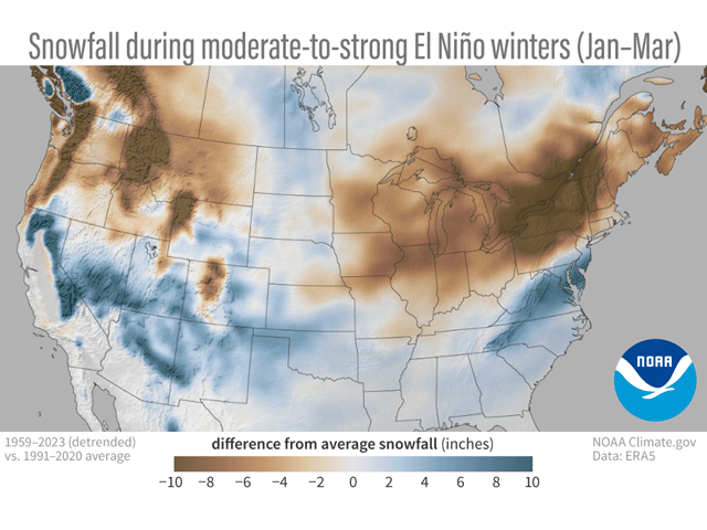
Snowfall differences from average in the Midwest during moderate-to-strong El Nino events are significant. In the 1959-2023 period of record, the Midwest winter snowfall totals in the winters with moderate-to-strong El Nino events are generally from 6 to 10 inches below average. Those departures are highly significant in the eastern Great Lakes and the upper Ohio River Valley. This suggests lake-effect snow will be lower this coming winter than in a year without a moderate-to-strong El Nino on the scene.
Seasonal forecasts from the NOAA Climate Prediction Center (CPC) indicate an 80% chance El Nino conditions will last through the Northern Hemisphere spring season. There is also a 75% to 85% chance of this El Nino becoming a "strong" event. The latest CPC Pacific guidance shows sea surface temperatures from 1.5 to 3 degrees Celsius above average in the eastern equatorial Pacific, reflecting El Nino values. The CPC also noted "tropical Pacific atmospheric anomalies are also consistent with El Nino."
More details on El Nino's potential effect on snowfall this coming winter are available here: https://www.climate.gov/…
Bryce Anderson can be reached at Bryce.Anderson@dtn.com
(c) Copyright 2023 DTN, LLC. All rights reserved.


Comments
To comment, please Log In or Join our Community .