

Ag Weather Forum
Heavy Precipitation Forecast for Southern Corn Belt

It is no secret that the southern end of the Corn Belt largely did without rain as the last system went through over the weekend. Rains occurred farther north but were more "maintenance" rains, or closer to normal for the week than anything overly heavy. That was the start of a different pattern here for this week, though, as now more disturbances will flood the Corn Belt with potential for scattered showers and thunderstorms.
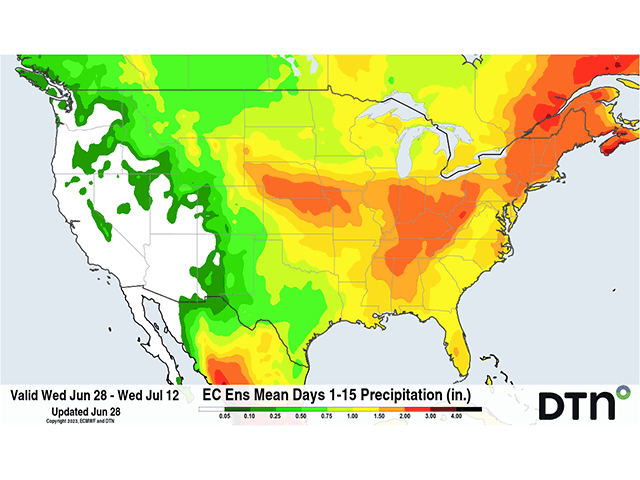
An upper-level ridge, which is bringing record heat to Texas, is bumping up into the south-central U.S. just enough to cause "ridge-riding" thunderstorm clusters to move through the southern end of the Corn Belt through this weekend. Rainfall is forecast to be really good in this area, from Nebraska to the Ohio Valley. Model ensembles are indicating a good 1 to 2 inches of widespread rainfall across this region and may help to ease concerns about the building drought, which is likely to show further degradation on Thursday morning's update. I wrote about how the drought picture may change in a blog on Tuesday here: https://www.dtnpf.com/….
The pattern certainly is a good change from what this part of the country has seen over the last couple of months, and that may continue next week as well. Over the weekend, we will finally see an upper-level trough that is sitting out in the West move eastward. It will push down the upper ridge across Texas and eliminate the extreme heat, but it will also change the storm track a bit farther to the south. That front is looking to stay active across the Southern states all next week, and models indicate the southern end of the Corn Belt may catch some of this rain as well, though maybe not into Iowa or central Illinois and Indiana.
P[L1] D[0x0] M[300x250] OOP[F] ADUNIT[] T[]
Instead, these areas -- and those farther north in the Corn Belt -- could catch a break with a system moving through Canada. Its cold front will slide through the Corn Belt next week, and models are producing areas of showers and thunderstorms as it passes through. The front is not a very fast-moving entity, so there is some potential for some decent rains for a lot of the northern Corn Belt as well, though models have been flip-flopping on that potential. But additional rains into the southern Corn Belt look very good as that front settles in during the second half of next week, especially if that front stalls out near the Ohio River as suggested by the recent European Centre for Medium-Range Weather Forecasting (ECMWF/European) model run. The American GFS model is much more erratic about this front's movement later next week. But either way, thunderstorms are in the forecast.
Rainfall during the summer is heavily dependent on the development of thunderstorm clusters, which have a strong tendency to bring heavy rainfall to localized areas and light-to-little rainfall in others. The clusters that moved through this week will definitely have that tendency, as there are no significant systems that will produce the storms -- only small disturbances moving over the top of that ridge across the South. The trough that moves through this weekend, and the front with it, changes that a bit for next week, as storms will be more closely located to where those fronts go and a bit more widespread as the fronts move. But thunderstorm clusters will still develop along these fronts and produce most of the rainfall.
They also come with significant severe weather risks. In particular, storms that ride ridges often turn into Mesoscale Convective Systems (MCSs) that can have a mind of their own. MCSs are often associated with severe winds and hail, sometimes tornadoes, and locally heavy rainfall. It is also a preferred setup for derechos, or long-track windstorms that produce widespread sustained wind damage and hurricane-force wind gusts.
Commodity markets have certainly taken note of the improved rainfall forecast for the driest areas of the Corn Belt this week with strong downward trends. However, even a two-week period of good rainfall cannot undo the last two months of dryness and drought that have built up across this region. Crop conditions have taken a nosedive in these areas. You can read more about current crop conditions here: https://www.dtnpf.com/…. To read more about how the forecasts might affect the commodity markets the rest of the summer, see https://www.dtnpf.com/….
The promise for improved rainfall has been a long time coming, but with crops in poor shape, just how much improvement can we expect if the rainfall does indeed fall as forecast? That's hard to understand. Corn and soybeans are already starting to get into their reproductive stages, and yield reduction increases by the day. It is especially difficult when we talk about the reality of these being scattered thunderstorm clusters, which will miss just as many areas as they hit. Not all areas in the path of these storms are going to get good rainfall. There will be areas that disappoint.
Sustained, above-normal rainfall over the entire region is going to be needed, and that is a tall order. Mother Nature will have her say in the matter, but the forecast is not likely to turn out exactly as predicted. With models changing their tune, sometimes with every model run, and their poor record at forecasting thunderstorms, especially beyond the next three to five days, we could see some differences in the sentiment over the next week or two. But for now, the forecast is a favorable one for those hardest hit by drought on the southern end of the Corn Belt.
To find more weather conditions and your local forecast from DTN, head over to https://www.dtnpf.com/…
John Baranick can be reached at john.baranick@dtn.com
(c) Copyright 2023 DTN, LLC. All rights reserved.
Comments
To comment, please Log In or Join our Community .