

Ag Weather Forum
Severe Storm Threat Increases with Heavy Rain Forecast
In yesterday's blog where I discussed the rainfall potential, I made a mention of a higher risk of severe weather. So far this morning, as of 11 a.m. CDT Thursday, June 29, that outlook was probably understated.
You can find yesterday's discussion about the heavy rainfall potential here: https://www.dtnpf.com/….
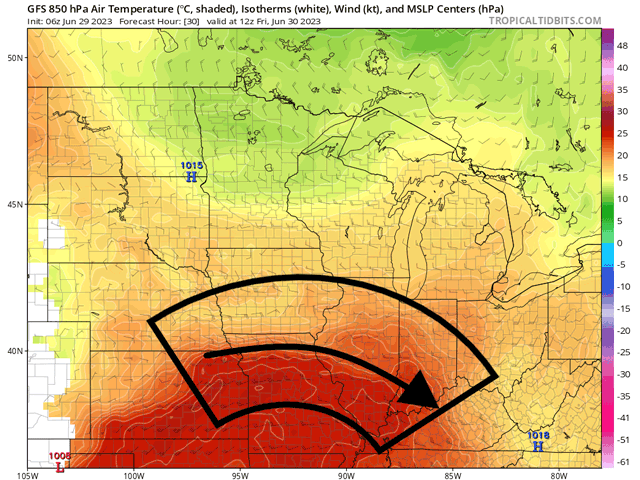
The ridge across the South-Central U.S. is the perfect opportunity for just about any disturbance moving from the western U.S. to ride along the rim of that ridge, feeding off the extreme heat and moisture pool underneath. These so-called "ridge riders" are a typical place for clusters of thunderstorms to develop and present a greater risk to become severe. It is also a great setup for producing derechos, long-duration windstorms that create continuous storm damage and hurricane-force winds.
P[L1] D[0x0] M[300x250] OOP[F] ADUNIT[] T[]
Through at least Saturday, clusters that develop along the edge of the ridge will have a strong potential for developing damaging winds and hail with that main corridor being from the Central Plains through the Ohio and Tennessee Valleys.
One of these has started to take shape from morning convection in Illinois and Indiana, riding the ridge south-southeast into Kentucky and Tennessee. Although strong and severe storms will be possible out of this cluster through the afternoon, a derecho-type event is not expected. However, it may interfere later with another cluster that formed along the Nebraska-Kansas border early this morning that has moved along the Iowa-Missouri border and is now getting into west-central Illinois. The forecast for this cluster is to take a southeastern turn through Illinois, following the edge of the ridge. This system is in a much better upper-air environment to promote widespread wind damage through the afternoon, with potential for those hurricane-force gusts at times, likely classifying it as a derecho if it indeed is able to eclipse 75 mph wind gusts in several spots, and is able to sustain the wind damage reports coming out of the previous convection.
However, it may run into the remnants of the cluster further down the line in Kentucky and Tennessee, which could disrupt the system and its impacts.
These will not be the only two clusters that form. Small-scale and global models agree on more disturbances moving through the area through Saturday. It is difficult to assess how many of these clusters may develop, but each will have the potential for more severe weather and derechos as they ride along the ridge. Their path and track may be slightly different than the last as well, not hitting the exact same areas over and over again, though some may overlap. In addition to wind damage, extremely large hail and tornadoes will also be possible.
After Saturday, the final trough in the pattern, which is now situated near the Grand Canyon, will come through and destroy the ridge, ending the threat of ridge-riding severe thunderstorm clusters. Though many in the path of these storms will be hoping for rain, the concurrence of strong winds and potential hail may be another kick to crops that have endured poor weather for the last couple of months.
To find more weather conditions and your local forecast from DTN, head over to https://www.dtnpf.com/…
John Baranick can be reached at john.baranick@dtn.com
(c) Copyright 2023 DTN, LLC. All rights reserved.

Comments
To comment, please Log In or Join our Community .