
Ag Weather Forum
How Might Drought Monitor Change This Week?
Due to a stalled front in the Northern Plains and a system moving through the Corn Belt over the weekend into early this week, the U.S. Drought Monitor may see some significant changes when it is released June 29. Data for the week ending at 7 a.m. CDT Tuesdays are used for the update to the Drought Monitor, which is released by the National Drought Mitigation Center Thursday mornings at 7 a.m. CDT. With that rain now in the books, we can see what changes may occur when it is released.
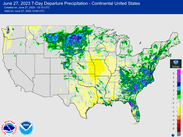
The attached image to this story shows how much rain relative to normal the country saw over the previous week. Precipitation is not the only driver of changes to the Drought Monitor, but it is usually the largest factor. You can find more information about how the Drought Monitor map is drawn here: https://www.dtnpf.com/…
Over the last week, heavy rains fell in a lot of places. The Northern Plains was an area of especially good rainfall. Most of the Dakotas, southeastern Montana, eastern Wyoming, and northern Nebraska saw above-normal rainfall for the week with a front that stayed active all week long, and heavy rain that came from a system that moved through Friday through the weekend. Large areas saw rainfall that was one-to-three inches above normal, not just in total. Some of these areas were in drought or increasing dryness, which should put those concerns to bed for a while. The update to the Drought Monitor should be favorable for improvement here.
P[L1] D[0x0] M[300x250] OOP[F] ADUNIT[] T[]
The Southeast and East Coast also found favorable rainfall from a system that was stuck there all last week and another that moved into the region over the weekend and early this week with good rainfall. The Southeast had some dryness and drought issues, mostly in Kentucky and Tennessee, where rainfall overlapped with good amounts that should lead to further reduction. Areas from the Mid-Atlantic may see some improvement in drought as well.
But it's not all good news. Rainfall was variable as it moved through the Corn Belt and most areas that ended up seeing rain only saw near-normal amounts. Small stripes from northern Iowa to northern Indiana and from northern Minnesota to Lower Michigan saw some near-to-above normal rainfall that may cause some reduction in some spots. Some stripes of better rainfall also occurred from southern Nebraska through parts of Texas. But that was interspersed by areas that received no such beneficial rainfall, so it is hard to determine how those at the National Drought Mitigation Center will draw their categories for these areas.
What is more certain is those areas that were missed, yet again, from southeastern Nebraska and eastern Kansas through southern Iowa, all of Missouri, and most of Illinois south of I-80. With areas already facing drought, conditions are likely to degrade yet again. Those that live in these areas are quick to point to the worsening conditions in their yards and fields as proof that the drought is real and really bad. Degradation of the ongoing drought in these areas is very likely.
It is not official today by DTN, but the rain that has fallen over the last week will produce some improvements on this week's Drought Monitor, while also showing areas of degradation.
We will talk about changes to the Drought Monitor and its effect on commodity markets in this week's "In The News" segment, which will be released Thursday afternoon. You can find more videos on the ongoing drought situation from DTN in the Special Reports tab on this page: https://www.dtnpf.com/…
To find updated radar and analysis from DTN, head over to https://www.dtnpf.com/…
John Baranick can be reached at john.baranick@dtn.com
(c) Copyright 2023 DTN, LLC. All rights reserved.