
Ag Weather Forum
Concerns About Increasing Drought in Corn Belt Mounting, Some Optimism Lies Ahead
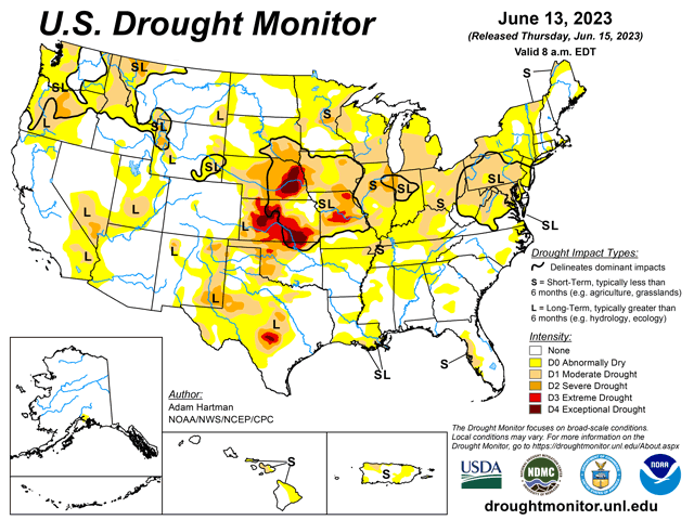
The U.S. Drought Monitor update this morning pointed to drought increasing across much of the Corn Belt, despite some areas of showers that moved through last weekend and early this week. Heavier rains fell across parts of eastern Wisconsin through Ohio and Pennsylvania after the cutoff time for the Drought Monitor, which may come into play next week.
But, overall, another dry week in the Midwest continues to increase concern about this year's crops. Yet not all hope is lost so early this season: The weather pattern is a lot less stagnant than it was from mid-May to early June, which will produce more systems moving through the country.
A system that is currently in the Canadian Prairies and Northern Plains will shift down into the Southeast during the weekend. It will be a slow mover, which is typically a good sign, but models have all sorts of inconsistencies in the forecast coverage and amounts as the system moves through. There just does not seem to be enough for the system to work with to create widespread areas of showers and thunderstorms for much of the Corn Belt that would turn around conditions for many areas. And this system will also miss a large portion of the Eastern Corn Belt as it moves through. Areas in the west certainly have good chances for rain, but as the system approaches the Mississippi River on Sunday, it shears apart with one piece of energy headed toward Hudson Bay and another going down into the Southeast, splitting around the eastern Midwest. Some areas may still catch some rain that need it, but major portions of Wisconsin and Illinois eastward are favored to remain dry.
Temperatures are also on the increase with a change to the upper levels next week. A ridge in Mexico is going to expand northward a bit and try to connect with another that will move into the Hudson Bay area. This should create a temporary block in the pattern and keep much of the Corn Belt dry. It is also a source of heat and should create well-above-normal temperatures across the Midwest. Highs approaching or exceeding 90 are currently forecast for a large section of the country from Texas into central Canada, with triple digits across the Southern Plains most of the week.
P[L1] D[0x0] M[300x250] OOP[F] ADUNIT[] T[]
However, there will be a deeper trough moving into the West that will produce some energy to create precipitation. The block will mean that any energy stays locked up in the Canadian Prairies and Northern Plains, which may include some of the drier areas around the eastern Dakotas and northwest Minnesota. But the block is not forecast to last long.
The southern piece is forecast to shift westward into the Rockies while the eastern piece drifts eastward to the Canadian Maritimes. That allows a channel through the Corn Belt for a storm system or systems to pass through. In response, both the European and American models increase chances across the Corn Belt late next week and weekend.
And while that is too far off for models to accurately predict precipitation amounts or coverage, it does point to another potential period of increasing rains for areas that are becoming desperate for good rainfall.
We must note, however, that models have been inconsistent and have only recently come upon this more active sign as we head toward the end of June and into July. They may easily flip drier again. Without any great signals coming from the Pacific Ocean as El Nino continues to take shape and the tropical forcing mechanisms remain weak, models are likely to make some changes as we go along.
Much talk on Twitter has been made about how bad the drought is becoming and how poorly crops look at this point of the season in some areas. I have seen lots of people trying to compare this season to the drought of 2012. But that is a completely different situation. Drought really came on when a "death ridge" developed in July 2012, promoted by La Nina. Dryness and extended heat sapped what little moisture was left in soils. That situation is not forecast for July 2023. Instead, there should continue to be a zone where showers and thunderstorms develop, which may occur over a good portion of the Corn Belt. Hybrids in 2023 are also better at dealing with drought stress than in 2012, despite that only being 11 years ago.
My panic button has not been set just yet, but that doesn't mean that the concerns aren't valid. Soil moisture across the Corn Belt is currently worse off than it was in 2012 at this point in the year. So much of the region is now hand-to-mouth when it comes to rainfall. And areas that do get missed or receive only light precipitation going forward are unlikely to have the full season that was hoped for this spring.
The likelihood of a cool summer is fading away, giving rise to more concerns about heat stress throughout the rest of the season. And areas in the far west that have gotten some good rain recently may start to turn drier again with heat increasing. Texas is certainly a concern for that to occur.
To find more weather conditions and your local forecast from DTN, head over to https://www.dtnpf.com/…
John Baranick can be reached at john.baranick@dtn.com
(c) Copyright 2023 DTN, LLC. All rights reserved.

Comments
To comment, please Log In or Join our Community .