

Ag Weather Forum
Severe Storms, Derecho a Threat to Southern Plains Thursday

Another day of severe weather is on tap across the southern tier of the United States on Thursday, which includes strong winds and a potential bow echo or derecho in the Southern Plains.
On Wednesday, from northeast Texas to northeast Oklahoma through Georgia and north Florida, multiple clusters of severe thunderstorms moved through all day long, which resulted in extremely large hail and more than 300 reports of damaging winds. The setup was actually very good to produce a derecho.
According to the National Weather Service, a derecho is defined as a sustained severe windstorm produced by strong thunderstorms that have continuous severe wind gusts over 58 miles per hour with several over 74 mph (hurricane strength) and last for more than 240 miles. But the threats did not materialize in large part because so many clusters of thunderstorms "muddied" the atmosphere and caused disruptions to the rare event. A derecho occurs a couple of times each year across the U.S. and the next opportunity may be today.
P[L1] D[0x0] M[300x250] OOP[F] ADUNIT[] T[]
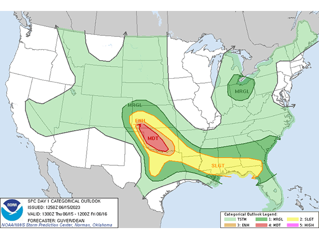
While the setup is not as good as yesterday across the Southeast, there are no clusters of thunderstorms expected that would disrupt its development. So, in essence, today's threat is greater than yesterday. The Storm Prediction Center (SPC) has outlined a moderate risk of severe storms for portions of Kansas and Oklahoma.
That initial burst of storms is being forecast by the SPC and most short-range models from southwestern Kansas to the northern Texas Panhandle this afternoon. If those storms are able to congeal into a line of storms, they will be in an area with significant potential to form a Mesoscale Convective System (MCS), which is a term meteorologists use to describe a collection of thunderstorms that act as a system and typically last for long stretches of time and distance and can produce severe weather.
If an MCS can create continuous severe wind gusts and some being hurricane-strength, then they get classified as a derecho. The environment is good enough to raise alarms for this area of the country later today and tonight.
MCS's or derechos may also produce large hail and tornadoes, which is also a high risk today, especially with the initial development of the storms before becoming an MCS or derecho. Those in the area today should pay extra attention to watches and warnings from the National Weather Service and SPC.
To find updated radar and analysis from DTN, head over to https://www.dtnpf.com/…
John Baranick can be reached at john.baranick@dtn.com
(c) Copyright 2023 DTN, LLC. All rights reserved.
Comments
To comment, please Log In or Join our Community .