

Ag Weather Forum
Needed Rain Coming, but Will Delay Planting for Plains, Midwest
It has been an active spring season and areas in the eastern Midwest and across the South have certainly noticed as their soil moisture has been adequate or a bit too wet at times. Some areas in the Western Corn Belt have seen some improvements in soil moisture as well.
The USDA Crop Progress Report that was released on April 22 noted some decent improvements in both top and subsoil moisture across the Dakotas, Nebraska, Minnesota, Iowa, Missouri, Wisconsin and Illinois.
However, these areas still have some extensive dryness and need more rain. There is not a lot of built-up moisture to supply crops deep into the growing season. At least not currently. And the southwestern Plains have essentially missed out on most of the active weather. Outside of the Texas Panhandle, eastern Colorado, Kansas and most of Oklahoma have had below-normal precipitation this spring. That also extends into the Northern Delta.
P[L1] D[0x0] M[300x250] OOP[F] ADUNIT[] T[]
Mother Nature will do her best to change things a bit and she'll do so providing a good setup for producing heavy rain across the middle of the country. An upper-level ridge, which is currently in the Southwest United States, and bringing 100-degree temperatures into the desert, will shift to the eastern portions of the U.S. by April 26. It will try to anchor itself there going into May, though it will probably shift around a bit between the Plains and East. It is not forecast to be overly strong, which allows disturbances coming from the Pacific to move into the middle of the country and bring thunderstorms capable of heavy rain.
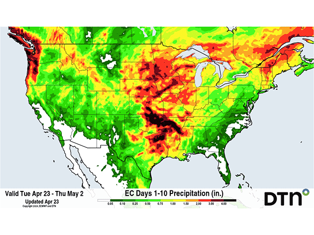
Two such systems will come in rapid succession starting April 25 and last into April 29 with areas of showers in the region. Widespread coverage of 1-3 inches of rain is forecast for much of the Plains and Midwest with this pair of systems.
The heavy rain will not come to everyone as forecast, as it is brought by thunderstorms, which leave patchy areas of heavy rain interspersed with areas of lighter rain. But this does bring a lot of needed moisture to drier areas. The thunderstorms will also have significant risks for severe weather for multiple days in a row -- a storm-chaser's dream -- but a warning for those that need to be outside working.
More disturbances will move off the Pacific and into the West next week. By then, the main axis of the ridge should shift more into the Mississippi Valley, which limits the scope of the rainfall and pushes the majority of the heavy rain and severe thunderstorm threat more into the Plains with lesser amounts east of the Mississippi River.
The rain should mostly be a blessing to these areas. Long-term moisture deficits remain across a lot of the Western Corn Belt and dryness and drought has been building around Kansas in recent weeks. The inclusion of good rains, and potential for heavy amounts over the next two weeks should stock soils with good rainfall for the growing season. It may cause some delays to spring planting, but the rainfall is likely to be regarded as beneficial.
The active period looks to slow down a bit mid-May, but you can be sure that systems will still be moving through the country. If farmers have some time to get out into their fields before the rain starts Thursday or Friday, it may be best to make the most of the opportunity now. They might not get a better chance until later in May, which is not guaranteed either.
To find more weather conditions and your local forecast from DTN, head over to https://www.dtnpf.com/…
John Baranick can be reached at john.baranick@dtn.com
(c) Copyright 2024 DTN, LLC. All rights reserved.

Comments
To comment, please Log In or Join our Community .