

Ag Weather Forum
Rain Arc Leaves Many Areas Dry
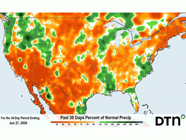
Through the first 27 days of June, only the occurrence of a once-in-every-100-years tropical system rain kept the entire Midwest from recording below-normal precipitation. Tropical Depression Cristobal dragged enough rain into the eastern half of Iowa, southeastern Minnesota, Wisconsin and Missouri to put the precipitation totals into the above-normal category for a 30-day stretch from late May into late June.
For the rest of the central United States, however, the situation has not been as favorable. Modeled precipitation totals for that same 30-day period show many locales posting less than 50% of normal precipitation. And this comes in the time when moisture loss from ground drying and evapotranspiration can swallow up a half inch of rain in just a couple days. Some easing in northern areas has no doubt occurred following heavy rain and some flooding during June 28-29. However, much of this northern tier of the Corn Belt was so far behind on precipitation that one occurrence will not be enough to solve the deficit.
Forecasts through the next 10 days show an arc of precipitation during the next week from -- again -- the far Northern Plains roughly southeast to the Mississippi and lower Ohio Valley area. For growing areas outside this arc, the trend is drier. And even light showers offer minimal lasting moisture. Indianapolis, Indiana for example has around 0.40 inches precipitation indicated through July 1. The evapotranspiration total in that same period is more than 0.25 inches per day. That light precipitation will not last long.
As noted in a blog item on June 22, NOAA and USDA note that much of the North Central U.S. region went into the first full week of astronomical summer with below-normal soil moisture. That's a big contrast to the very wet conditions one year ago. The upcoming 10-day period does not offer a meaningful change in that trend.
P[L1] D[0x0] M[300x250] OOP[F] ADUNIT[] T[]
Issues that will be watched closely over the next several weeks include:
-- Increase in crop water use and stress to crops and rangeland in areas where soil moisture deficits are increasing. In areas with no irrigation access, a tailing-off of crop condition will certainly be noted. And, in areas where irrigation can be done, it's been go-go-go already. As one southwest Plains grower told me, "Pivots are not getting a break this year. And last year they only had to work part time."
-- Crop condition ratings. The next two weeks will be important to get an idea of the health of the corn factory for the 2020 crop. With pollination close at hand, time is running out for plant growth and development ahead of transferring nutrients to the new grain.
-- Temperatures have a high probability to be above normal through the first 10 days of July. That offers a concerning element regarding the ability of corn pollination to maximize (setting kernels to the end of the ear).
-- Perhaps even the USDA projected corn yield of 178.5 bushels per acre will get called into question if early July does indeed resemble the month of June.
Depending on a once-in-a-century occurrence happening again during the crop season seems like a stretch.
Bryce Anderson can be reached at bryce.anderson@dtn.com
Follow him on Twitter @BAndersonDTN
© (c) Copyright 2020 DTN, LLC. All rights reserved.
Comments
To comment, please Log In or Join our Community .