South America Calling
A Return to Normal La Nina Pattern Unfavorable for Argentina, Southern Brazil
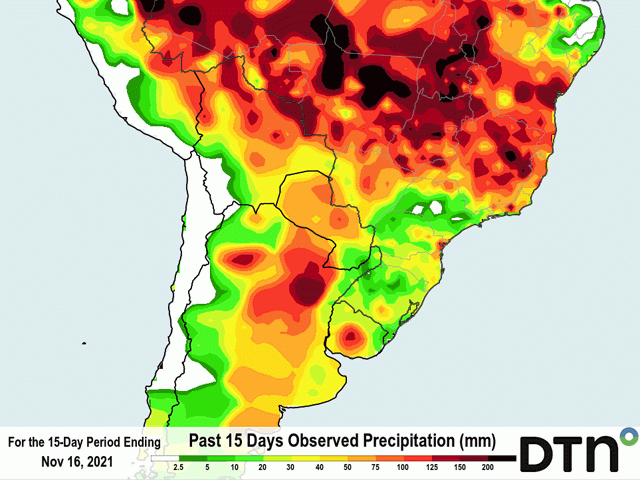
La Nina continues to be the highlight of the weather scene for South America, but a two-week break from the pattern was definitely needed in Argentina. Rainfall during the first half of the November has been on the order of 50 to 100 millimeters (roughly 2 to 4 inches) across most of the country's growing regions according to analysis by DTN. That was good enough to turn poor planting and growing conditions for corn and soybeans into better soil moisture, with some reserves to last a couple of weeks.
Those reserves look like they will be needed. The brief pattern break is returning back to the one we typically see in a La Nina spring and early summer -- long dry stretches broken up by sometimes timely, but brief showers as fronts quickly move through, leading to below-normal rainfall.
Southern Brazil states from Sao Paulo south through Rio Grande do Sul, did not fair as well so far in November. After good rains in October, precipitation has slowed down in November. Through the first half of the month, rainfall amounts up to 50 mm (around 2 inches) are behind normal for that stretch of time. This portion of the country has only received about half of the rain it usually does during the first two weeks of November. After a wet October, the drier weather is not as concerning on its own, especially since a front currently moving through the region Nov. 16-18 is not included in the calculation. But this area is seeing that La Nina pattern return as well, and quick-hitting shots of showers are not favorable for corn and soybean development when soil moisture reserves are low.
P[L1] D[0x0] M[300x250] OOP[F] ADUNIT[] T[]
Those reserves are a bit higher in Argentina and all of it will be necessary with the pattern change. As storm systems pass by, we can expect 10 to 20 mm (0.4 to 0.8 inches) of precipitation will occur every five-to-seven days in a few spots while it will be lighter in others. Where the showers hit will be fine, as getting that much rain every week is not ideal, but manageable for developing crops. But where they miss, going sometimes two weeks without rainfall will deplete soil moisture reserves quickly and stress crops.
Model simulations from both the American GEFS and European suggest this drier pattern will continue through December, typical of La Nina. With much of the crop in southern Brazil being planted early this year, pollination will begin during the month for a good portion of corn and soybeans. A lack of moisture reserves will mean that timely showers will be necessary for good yields in the face of below-normal total rainfall.
We have seen this before. In the 2019-20 and 2020-21 seasons, periodic rainfall was timely in the face of drought conditions to save the crop from being devastated. And there was also another factor.
With a rather long growing season, Argentina has two planting periods on corn to reduce the risk of dry stretches impacting yields. The earlier-planted crops in September and October are the ones most affected now with pollination coming up in December.
But that has only accounted for roughly 29% of the total expected crop in the country. On average, about 38% of the crop should have been planted thus far. Seeing the drier conditions in October likely pushed producers to weigh heavier on later plantings in December.
With pollination coming later in the summer and early fall, later-planted corn has a better chance to ride out the effects of La Nina as it wanes in intensity in January and February. The bets seem to be on later-planted corn. Just how fast La Nina wanes will determine whether or not the bets pay off.
John Baranick can be reached at john.baranick@dtn.com
(c) Copyright 2021 DTN, LLC. All rights reserved.


Comments
To comment, please Log In or Join our Community .