
South America Calling
Argentina Continuing to See Good Rain Despite La Nina

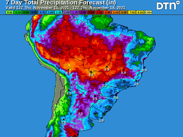
A front that moved through Argentina and southern Brazil late last week and weekend cleared out rains from a good week of precipitation and left dryness in its wake. From far southern Brazil through eastern Argentina, little in terms of precipitation has been seen since, indicative of the La Nina pattern we would expect.
Rainfall the week prior was good, however, and soil moisture likely stayed in favorable terms for continued spring planting of corn and soybeans, as well as early growth.
But western Argentina defied the pattern and near daily isolated to scattered showers developed across western areas of the country where it has been driest this spring. Since Nov. 8, 15 to 40 millimeters of rain (0.60 to 1.57 inches) fell in these areas between Nov. 8-10 and there were several spots where amounts eclipsed 60 mm (2.35 inches). That was more than welcome to continue the good rainfall that this portion of the world received last week as the La Nina took a pause.
P[L1] D[0x0] M[300x250] OOP[F] ADUNIT[] T[]
The pattern continues with faster-moving storm systems. A potent little system will bring widespread moderate to locally heavy rainfall through much of Argentina and possibly far southern Brazil Nov. 13-14. Another system will follow behind it early next week and models have started to come to an agreement that this system will bring more widespread showers through Argentina and then southern Brazil as well. After some dry days for some in eastern Argentina and southern Brazil, the outlook over the next several days is favorable for continued progress on corn and soybean planting, as well as early growth.
However, the pattern looks like it will go back into its La Nina "base-state" after that second system moves through. Models are showing much drier conditions that will follow for about a week afterwards. Soil moisture since the beginning of November has been good and will be able to sustain crops for a while, but it may be only a short-term benefit as La Nina is slated to continue through the summer months before letting up toward the fall.
La Nina typically produces lower precipitation across Argentina and southern Brazil during the spring and possibly summer months by limiting pop-up type showers and causing stronger systems to move more quickly through the region and not allowing showers to linger.
Early this spring followed this pattern well in Argentina. Systems were fast-movers and we did not see much shower activity outside of these systems. Southern Brazil saw much better precipitation than is typical as fronts stalled out in the region instead of moving into central Brazil.
Soil moisture from earlier this spring has carried into November really well even as showers have started to become more isolated with longer dry stretches. Soil moisture can be a little fickle in this area though as sandier soils drain a little more than elsewhere in the region. Drier stretches typically have a big impact in this region due to that fact.
La Nina is not going to give up anytime soon. Its impact will be felt through the growing season. While the event typically causes concern for corn and soybeans in Argentina and southern Brazil, it is not a given.
Timely rains, even if they do not amount in as much precipitation as a normal year, can still produce good results. Stronger storm systems can break up those dry stretches rather nicely. And if they come with a good frequency, can limit the expected negative impact.
John Baranick can be reached at john.baranick@dtn.com
(c) Copyright 2021 DTN, LLC. All rights reserved.
Comments
To comment, please Log In or Join our Community .