

Ag Weather Forum
Atmospheric River to Undercut Strong North American Ridge This Week
A giant upper-level ridge of high pressure is parked across much of North America on Jan. 30 and has been around for the last week. It is a typical feature during El Nino winters and, unsurprisingly, temperatures have climbed well above normal for a good portion of the U.S. and Canada. If that ridge sticks around, it will continue to be warm. But there will be some pressure on that ridge this week as a deep trough in the Pacific gears up to bring a lot of energy and moisture into the U.S.
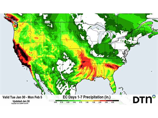
Labeled an atmospheric river for its transport of a steady stream of heavy moisture from the Pacific Ocean, it will mean a heavy dose of precipitation over California, much of the West, Plains and Deep South for several days.
When the atmospheric river slams into California starting Jan. 31, it will have picked up moisture across most of the large ocean, and its origination around Hawaii lends to the term "Pineapple Express" that you may hear from time to time. Storms that come from atmospheric rivers are notorious for dumping large amounts of heavy precipitation across the West Coast that can extend farther inland as well. This one will hit California the hardest but will also spread moisture through most of the Intermountain West. Through Feb. 2, liquid equivalents of 1 to 2 inches in the valleys and 3 to 6 inches in the mountains will be likely in California and up to 2 inches in the mountains across the rest of the West. Where it is cold enough for snow, it will most likely be measured in feet and the Sierras in California are bracing for it.
But the storm system won't just affect the West. The stiff push from the subtropical jet stream will cut underneath that ridge in the middle of the continent and bring areas of precipitation farther east as well.
P[L1] D[0x0] M[300x250] OOP[F] ADUNIT[] T[]
Models are producing a low-pressure center in the Texas Panhandle on Feb. 2. But unlike many systems that originate here, and the monster winter storms that occurred earlier in January, storms will not move northeast toward the Great Lakes. Instead, the ridge will direct it eastward through the Deep South and Southeast for Feb. 3-4.
Leftover moisture from the Pacific Ocean and the ingestion of moisture from the Gulf of Mexico should lend to widespread precipitation near the low center to the south, including areas of thunderstorms that may turn severe. However, the moisture is the most important feature, as it may cause flooding over areas that have seen plenty of rain over the last week. Rainfall amounts of 1 to 3 inches are forecast for the southeastern Plains through the Southeast. The moisture should help further reduce drought in the Delta region.
But the moisture will not be limited just to the storm track. Though it will find resistance from the ridge, moisture should pool up farther north through the Plains as well. A band of moderate rain and snow will extend north of the low through the Canadian border and into Saskatchewan and Manitoba. Temperatures farther north could be cold enough to turn some of this into snow, though models are still working out those details.
As of the current writing, the greatest threats for significant snow are from the foothills of Wyoming and Montana up through central Saskatchewan on Feb. 3-4 where amounts could exceed 6 inches (15 cm). Depending on temperatures and the evolution of the plume of moisture, those threats may extend eastward into the Nebraska panhandle through the Black Hills as well, but that is uncertain.
The Midwest will largely be spared the brunt of the storm due to the ridge and instead will find high temperatures that may break records this weekend.
The atmospheric river will not end this week as the main trough will settle in the West all next week and bring at least one more large push of heavy moisture into California Feb. 4-5. How this storm develops for the rest of the West and east of the Rockies is yet to be determined, but with the ridge likely getting nudged eastward, that could open up the Plains and Midwest to more chances for some wet weather.
To find more weather conditions and your local forecast from DTN, head over to https://www.dtnpf.com/…
John Baranick can be reached at john.baranick@dtn.com.
(c) Copyright 2024 DTN, LLC. All rights reserved.

Comments
To comment, please Log In or Join our Community .