

Ag Weather Forum
Can Argentina Maintain its Excellent Crop Conditions Going into February?

From Jan. 17-23, satellite rainfall estimates across the state of Buenos Aires, in east-central Argentina, show little to no rain has fallen and rainfall anomalies were 20-50 millimeters (0.75-2 inches) below normal. Soil moisture levels have also started to trend downwards to near-normal levels across the state in the past week in wake of the beneficial rainfall that occurred through much of December into early January.
Forecast rainfall through next week across Argentina shows a few chances for isolated to scattered showers, but will the rainfall be enough to keep crops in good and excellent condition heading into February?
P[L1] D[0x0] M[300x250] OOP[F] ADUNIT[] T[]
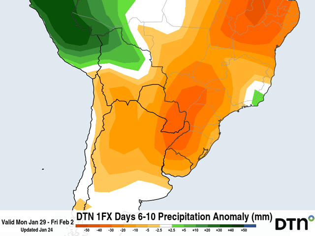
While the precipitation outlook for next week shows below-normal rainfall extending from northern Argentina into central Brazil, this doesn't necessarily mean that no rainfall is expected. Both the ECMWF (European model) and the American GFS model show isolated to scattered showers developing across portions of central Argentina by the middle of next week as low-pressure systems move across southern Argentina. Rainfall totals next week could approach up to 20 mm (0.75 inches) across the provinces of Buenos Aires and La Pampa.
Looking elsewhere, towards the provinces of Santa Fe and Cordoba, in northern Argentina, uncertainty is higher regarding the rainfall potential next week. As low-pressure systems slide by to the south, the extent of precipitation to the north will be highly dependent on how far north the systems' cold fronts can extend. Currently, the best chances for scattered rainfall will be across far southern areas of Cordoba and Santa Fe next week. In these areas, up to 10 mm (0.40 inch) of rain is forecast. Model guidance suggests that precipitation next week across Argentina looks hit-and-miss and some fields may be able to maintain decent soil moisture if they receive rainfall. However, fields that stay mostly dry next week may run the risk for soil moisture dropping below normal.
In addition to the chances for light precipitation next week, temperatures will continue to trend towards above normal. Throughout this weekend, cooler air will remain intact across northern Argentina as temperatures will be up to 3 degrees Celsius (5.5 degrees Fahrenheit) below normal. This relatively cooler air will get replaced by higher temperatures from southern Argentina advancing north throughout next week. By Feb. 1, much of the main growing areas in Argentina will see temperatures rise to 5 C (9 F) above normal. The European model predicts that afternoon high temperatures across parts of La Pampa, Cordoba, and western Buenos Aires could approach 34-38 C (93-100 F) from Jan. 30-Feb. 1.
In a report released by the Buenos Aires Grain Exchange on Jan. 25, the report stressed the importance of additional rainfall through the growing season to maintain its current estimates for total soybean and corn production. As of Jan. 25, 92% of soybeans were rated in normal and excellent condition while 94% of corn was rated in normal and excellent condition. Compared to the report that was released a week ago on Jan. 18, 98% of soybeans were rated in normal and excellent condition while 97% of corn was rated in normal and excellent condition.
The dry conditions that have taken place across Argentina over the past seven to 10 days have started to show some signs of negative impact on the crop ratings. There was a 6% reduction in normal and excellent soybean ratings while corn saw a 3% reduction from Jan. 18-25. Given the predicted rainfall amounts will be below normal through next week and temperatures will rise even more, corn and soybean ratings across Argentina could be at risk for diminishing again.
Looking through the month of February, precipitation outlooks for central Argentina are favored to be near or up to 10 mm (0.40 inch) below normal while more northern areas of Argentina could see precipitation favored to be above normal. The temperature outlook for most of the main growing areas in Argentina favors temperatures to be above normal. Parts of central Argentina are favored to be 1-2 degrees C (1.8-3.6 degrees F) above normal. Steady rains will be the key to maintaining the normal and excellent crops ratings, but as we venture into February, it will be worth watching how the corn and soybean crop in Argentina can hold up to potentially above normal temperatures.
To find more international weather conditions and your local forecast from DTN, visit https://www.dtnpf.com/…
Teresa Wells can be reached at teresa.deutchman@dtn.com
(c) Copyright 2024 DTN, LLC. All rights reserved.
Comments
To comment, please Log In or Join our Community .