

Ag Weather Forum
Will La Nina Develop Sooner in the 2024 Growing Season?
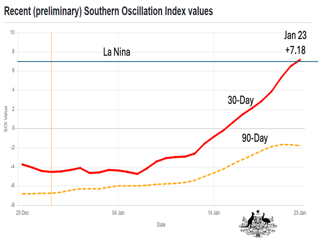
One of the key components of the closely watched Pacific Ocean El Nino-Southern Oscillation (ENSO) phenomenon is the measurement known as the Southern Oscillation Index (SOI). A description of the SOI on the NOAA website (https://www.climate.gov/…) noted, "The Southern Oscillation Index (SOI) tracks the atmospheric part of the El Nino-La Nina climate pattern by comparing surface air pressure anomalies at Darwin, Australia, to pressure anomalies at Tahiti. A positive SOI indicates La Nina, while a negative SOI indicates El Nino."
During the past two months, the SOI has shown a sustained trend away from negative El Nino values. As the last two weeks of January got underway, those values reached into La Nina category on a 30-day running average. The Australia Bureau of Meteorology (BOM) noted in a Pacific Ocean climate commentary that the SOI values Jan. 21 were +8.0, +3.4 and -0.3 on a 30- , 60- and 90-day average, respectively. On Jan. 23, the 30-day SOI average was +7.18 with the 90-day average at -1.77. (The SOI threshold for La Nina is +7.0).
This move does not mean that La Nina development is imminent. The Australia BOM commentary on the SOI trends highlights, "This follows more frequent periods of low-pressure anomalies over northern Australia, including the development of a monsoon trough over Darwin. Tahiti is also currently experiencing higher than average pressure."
P[L1] D[0x0] M[300x250] OOP[F] ADUNIT[] T[]
In addition, DTN Long-Range Weather Risk Communicator Nathan Hamblin looks for sub-seasonal atmospheric features, which develop and dissipate in a shorter time frame than ENSO, to cause some adjustment in daily barometer readings across the Pacific.
"The ECMWF (European forecast model) shows an extended period of westerly (Pacific) wind anomalies in early February, which should slow down any weakening of El Nino for the short term," Hamblin said.
Most forecasts call for La Nina to develop during the Northern Hemisphere during the late summer-early fall time frame. However, the U.S. forecast model suggests an earlier transition into La Nina. Hamblin looks for the Pacific move into La Nina to be on that earlier development as well.
"The DTN forecast is for La Nina to develop on the faster end of the model guidance, but probably slightly behind the faster CFS (U.S. model) timing," he said.
The timing of La Nina's development is a key feature when it comes to crop weather prospects for 2024, particularly during the summer, DTN Ag Meteorologist John Baranick noted in a recent Pacific Ocean commentary. "If we take the forecast of a developing La Nina ... there is one concerning trend -- a persistent upper-level ridge (high pressure) over the eastern half of the U.S.," Baranick wrote. "A ridge tends to limit precipitation while increasing temperatures." In other words, La Nina development sooner rather than later implies the potential for a hot and dry summer in the Midwest.
In summation: The Pacific Ocean SOI is starting to show La Nina-category values. That trend will bear close monitoring as the 2024 U.S. row crop season gets closer.
More details on DTN's Pacific Ocean commentary are available here: https://www.dtnpf.com/…
Bryce Anderson can be reached at Bryce.Anderson@dtn.com
(c) Copyright 2024 DTN, LLC. All rights reserved.

Comments
To comment, please Log In or Join our Community .