

Ag Weather Forum
Will There Be a Big Storm Next Week?

Precipitation during the last week has been a boon to drought reduction across large portions of the Plains and Midwest, but drought is still a big player in the United States.
Water levels on local rivers have increased, but there is still a ways to go to get some of the larger rivers up toward normal. Increased soil moisture and runoff will do the trick. But more rain is needed. A good time to bring in the rain is in the back half of the fall season prior to soil freezing. Soils count on fall and winter precipitation to set up the following growing season with ample moisture for germination and early growth.
So, will the U.S. see another big storm system next week?
P[L1] D[0x0] M[300x250] OOP[F] ADUNIT[] T[]
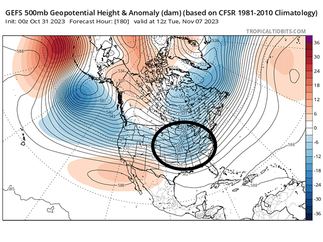
The ingredients appear to be there in the upper levels of the atmosphere. Currently, there is a ridge in the West all the way up into Alaska with a deep trough in the East with some sort of connection to a polar low moving its way into Hudson Bay. Further up the line, a trough is spinning in the North Pacific, intent on sending pieces of energy eastward next week. The western ridge could block up the pattern, forcing these disturbances to go north toward the Pole and then back down into the trough in Hudson Bay. That would be a warmer and quieter pattern for the U.S.
But that ridge is pretty weak and will allow those disturbances to move eastward through it and into the Eastern U.S. instead. One of those disturbances looks to accomplish that feat early next week, deepening in the East as it does so, which typically results in a large storm system east of the Rockies. And while the large-scale weather models agree on the setup and deepening of the trough over the Eastern U.S. early next week, they are all over the board with how a potential storm system may develop with it.
I discuss that with DTN/Progressive Farmer Associate Content Manager Elaine Shein as part of this week's Reporter's Notebook video here: https://www.dtnpf.com/…. At the end of the video, we show a collection of all the American GFS model runs over the last week's forecasting for early morning on Nov. 7. They are all valid at the exact same time. The only difference in each of these images is the time the model was run. Each run is different from the last. Sometimes it's drastic, and sometimes it's subtle, but there are huge swings in each run that do not convey a lot of consistency or confidence in the forecast for early next week.
Some of the models have a large storm system moving through. Some of them have a more muted storm system. Some have just a cold front sagging through. High pressure may be centered on the Northern Plains, Midwest, or Southeast. And precipitation amounts and types and temperatures come in various degrees and magnitudes.
That makes the forecast for next week a very difficult one. A meteorologist has to impart some meaning for what conditions that he or she expects, while also leaving the door wide open for changes to the forecast. The upper levels, which drive the weather at the lower levels, may insinuate a storm system coming. But that does not mean that it will, or that we can have any degree of confidence in what that storm system might entail, especially for localized areas.
This situation is not unique to next week. It's a relatively frequent occurrence, especially at a range greater than five days and during times of great change. Stagnant patterns usually show less of this variability between models. Patterns that are more active or depict large changes in the upper atmosphere tend to have the greater variability. So, will a storm system develop over the Central and/or Eastern U.S. early next week? The pattern supports it, but the details are yet to be determined.
To find more weather conditions and your local forecast from DTN, head over to https://www.dtnpf.com/…
John Baranick can be reached at john.baranick@dtn.com
(c) Copyright 2023 DTN, LLC. All rights reserved.
Comments
To comment, please Log In or Join our Community .