Ag Weather Forum
Why Central Brazil Rainfall Anomalies Do and Don't Matter
As I mentioned last week in this bog, https://www.dtnpf.com/…, the rainfall pattern in central Brazil has been disappointing for the start of its wet season, which began in late September. During the last 30 days, rains have been around, but sporadic and well-below normal in a lot of areas.
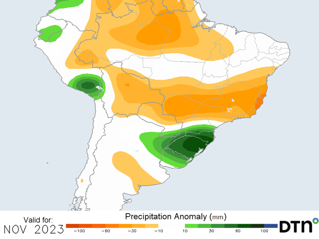
The forecast for the next week has improved and models are putting out some decent amounts in the region from Mato Grosso to Minas Gerais and points northward, but the forecast for November on-the-whole continues to be below normal. Long-term deficits remain and concern continues to be for the dryness in the region.
But we have to ask ourselves what "dry" means. In strict amounts, during the last 30 days, some areas of this region have had less than 25 millimeters (about 1 inch). Others have had more than 150 mm (about 6 inches). On average though, most places are somewhere between 60 and 125 mm (about 2.4 to 5 inches). That is largely below normal, and coming off of a dry season in which almost no rain fell for five straight months, the below-normal start to the wet season is somewhat of an issue.
Soybean producers here need a good start to the wet season to start planting on time and not have to worry about replanting. The concern is that soybeans that have already been planted could dry out and die if these showers disappoint, necessitating a replanting. Replanting soybeans would probably not affect the soybean crop too much, but it would certainly change plans for safrinha (second-season) corn and cotton planting early next year.
P[L1] D[0x0] M[300x250] OOP[F] ADUNIT[] T[]
However, getting 60-125 mm of rainfall in a month is not going to set back too many producers. Though temperatures are routinely in the 32-38 Celsius (90 to 100 Fahrenheit) range at peak heating during the day, that amount of rainfall is adequate for early development.
The forecast for November continues to be shaky in central and northern Brazil, but only when looking at comparisons to normal. Extended versions of the European ECMWF model show deficits below normal of 50-100 mm (about 2-4 inches) while the American GFS is more drastic with the dryness at 75-150 mm (about 3-6 inches) below normal. Even then, total precipitation from that same GFS is roughly 60-125 mm for the month of November and the ECMWF shows 100-200 mm of precipitation for the month.
On the low-end, precipitation amounts are low, but adequate for developing soybeans. On the high-end, many areas would still be able to build subsoil moisture during the month.
This is not to say that the deficits don't matter. They certainly do. When soils cannot build subsoil moisture during the wet season, the prospects for any safrinha crop production go down dramatically.
But the concern over the dry start should be a more muted point. The larger concern should be placed on the heavy rain that the southern states have endured during the last few months. Also in last week's blog, I mentioned the extreme wetness that has occurred in the state of Rio Grande do Sul and the neighboring area.
Rainfall records have been set for the month of October in some areas, and the forecast going forward is for more rain in the region. That should lead to further flooding damage and boggy soils, which will affect the remaining planting and crop development more than the overall "lack" of rainfall farther north. Southern Brazil may be where the more extreme conditions lie this season, though we will pay attention to both.
To find more international weather conditions and your local forecast from DTN, visit https://www.dtnpf.com/….
John Baranick can be reached at john.baranick@dtn.com
(c) Copyright 2023 DTN, LLC. All rights reserved.


Comments
To comment, please Log In or Join our Community .