
Ag Weather Forum
UPDATE: Weather Pattern Shift Is Coming Early, as Weather Models Dramatically Change Forecast
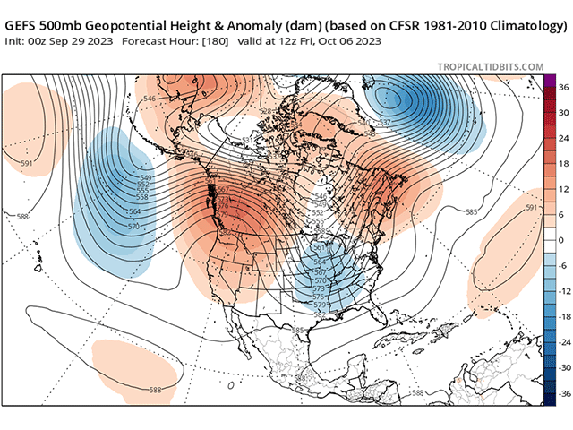
Well, of course, almost immediately after I wrote a story about a coming change in the weather pattern, the models take a dramatic turn. Starting with the evening runs on Sept. 27, models did a complete 180-degree turn in the upper-level pattern. Every run since then has been trending in the same direction, giving us confidence that a change is coming next week, not mid- or late October as previously thought.
You can read more about the reasons why the shift was expected to occur during the month here: https://www.dtnpf.com/….
Instead of the eastern ridge being a stout force at keeping western troughs from advancing, all versions of the American GFS and European ECMWF model now allow a trough coming into Western Canada next week to shove the Eastern Canada ridge eastward off the coast. That will allow a separate trough currently in the western U.S. to move eastward next week, instead of fizzling out.
The result is a strong cold front moving through the country between Oct. 3-6. The front will produce a good band of showers and thunderstorms up and down the Plains to the Mississippi Valley.
P[L1] D[0x0] M[300x250] OOP[F] ADUNIT[] T[]
The front is currently forecast to have showers waning as it travels eastward, though continuing to have some coverage east of the Mississippi River. Between the Rockies and Mississippi River, models are suggesting a widespread 0.5 to 1 inch of rainfall with pockets of heavier rainfall in the Southern Plains and in the Red River Valley of the North.
This comes on the heels of some heavier rainfall of similar magnitude late last week and weekend. Reductions in drought west of the Mississippi River will be possible, but so will harvest delays for corn, soybeans, and other summer crops. Those that plant winter wheat will gladly take the coming rains to improve soil moisture for establishment. Areas east of the Mississippi River are forecast to receive generally less than 0.5 inch of rain with more limited coverage.
The other effect will be to dramatically lower temperatures for the eastern half of the country. This weekend, temperatures will increase into typical mid-summer readings. Afternoon highs in the 80s and 90s Fahrenheit will be common going into early next week ahead of the front. But behind the front, those highs will drop some 20-30 degrees. Highs more in the 50s and 60s will be common by the end of the week. Morning lows will also be chilly.
Also, by the end of the week, it will be possible for frosts to occur across the Corn Belt. That is still being worked out by models and the potential examined, but is certainly possible. For those in the Northern Plains and Upper Midwest, that should be no surprise, as the average first frost dates are either in late September or the first 10 days of October. But for those farther south and east, it would be quite early.
The longer-range models are not sure whether this will be a permanent change or just a temporary one. It will take several more days to understand that. But if there has been any trend, it would be to keep the change a little more permanent for the month of October.
Even so, the placement of a western ridge and eastern trough would be important. The farther that ridge can extend into the middle of the country, the more limited the lower temperatures would be for those west of the Mississippi.
To find more weather conditions and your local forecast from DTN, head over to https://www.dtnpf.com/…
John Baranick can be reached at john.baranick@dtn.com
(c) Copyright 2023 DTN, LLC. All rights reserved.

Comments
To comment, please Log In or Join our Community .