

Ag Weather Forum
Weather Pattern Shift Coming in October?
Harvest seems to be going pretty well thus far. As of Sept. 24 on the latest USDA NASS Crop Progress report, corn harvest stood at 15% complete, compared to 13% on average. Soybeans were 12% complete, compared to 11% on average. That comes after some heavy rain moved through the Western Corn Belt late last week and weekend.
Much of the remaining crop is mature, at 70% for corn, and 73% for soybeans. As long as conditions are good for getting out into the fields, and they largely are, harvest should roll rather rapidly. A change in the weather pattern will be necessary to change the thought process for harvest progress. I noted the potential for that in a blog a couple weeks ago here: https://www.dtnpf.com/…. That change is still in the cards.
The heavy rain that moved through the Western Corn Belt late last week and weekend continued into the Eastern Corn Belt early-to-mid this week. It will take until Friday to clear out of the region. Normally, moderate-to-heavy rain over a widespread area would bog down harvest for a while. But with how dry soils have been during the last several months, and the growing drought conditions during the last several weeks, those dry soils have been and will gladly soak up the water quickly. Delays will be short-lived.
That is especially true with the temperature pattern for at least the next 10 days. A large ridge of high pressure currently sits over most of Canada and with a trough digging into the West and the current system leaving, temperatures will be on the increase going into the weekend. Widespread daytime highs in the 80s and 90s Fahrenheit will spread through most of the Corn Belt, and really most areas east of the Rockies going into next week.
That trough in the West will keep those areas cool and wet with periods of showers. It will also leak into the Canadian Prairies and northwestern Plains, where a front will be stalled out and bring periods of showers Thursday through a good portion of next week. That trough will finally be lifted northeast toward the middle of next week as another trough digs into Western Canada. Typically, that would mean a big storm system during the fall. Models prefer Canada and parts of the Plains and Upper Midwest to get the bulk of any precipitation and threats for more harvest delays.
P[L1] D[0x0] M[300x250] OOP[F] ADUNIT[] T[]
We will have to watch that one because it could be the precursor to a pattern change coming for mid-October.
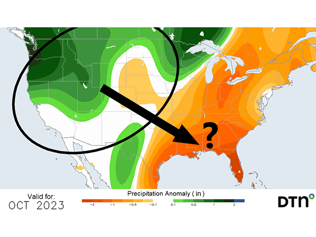
A trough in the West and ridge in the East are continuing to be the preferred setup through the end of next week. But we are getting hints in both the European ECMWF and American GFS model that we could see a flip near the middle or end of the month. The latest extended version of the ECMWF makes that flip around Oct. 15-18, while the GFS doesn't show a definitive change until the last few days of the month.
We are also getting hints of this flip when looking at history (strong El Ninos tend to produce a cold shot sometime in October into November east of the Rockies) and other weather patterns across the globe. The main one of that is the Madden-Julien Oscillation (MJO). It describes a band of thunderstorms that traverses the Pacific Ocean.
Depending on where it is located, it can change the energy in the atmosphere and where troughs and ridges are favored. The current forecast of the MJO favors a western ridge and eastern trough for the second half of October.
If and likely when it does occur, the eastern trough would bring much lower temperatures down into the country. We would also expect rain to shift from the West and Plains to the South and East as the pattern begins to look more like El Nino going into November.
Cooler and wetter would be a net negative for harvest progress for the last half of the fall season should it occur. In addition to delaying harvest, it may cause the need for more propane to be used for drying grain.
But it could be a good thing for winter wheat establishment. As long as temperatures do not get too cold where widespread continuous frost would be an issue, cool weather and increased rainfall chances for the South would help these areas recover a bit from the drought and improve establishment.
But even though we are getting hints at a pattern change in the longer-range models, they are not on board with the change in temperatures, nor are they expecting changes in the precipitation pattern. They still favor widespread warmth east of the Rockies and above-normal precipitation in the Plains and Upper Midwest. With models being so far off from the DTN forecast, the confidence is awfully low. There is a large potential for a bust, or that the MJO-related influences will be too weak to cause the actual change in the upper-level pattern for the second half of October.
One caveat to models in the longer-range though, is their inability to accurately forecast a significant cool down more than 10 days in advance. With this coming in the third week of October, that is well beyond their ability to accurately see that cool shot coming. It will be an interesting month for meteorologists to forecast, for sure, and one that could have major implications for the second half of the harvest.
To find more weather conditions and your local forecast from DTN, head over to https://www.dtnpf.com/…
John Baranick can be reached at john.baranick@dtn.com
(c) Copyright 2023 DTN, LLC. All rights reserved.

Comments
To comment, please Log In or Join our Community .