

Ag Weather Forum
Precipitation Continuing Into Next Week for Prairies
Harvest continues to wrap up across the Canadian Prairies. As of earlier this week, Manitoba was 76% complete and Saskatchewan was 91% complete. Last week, Alberta was 67% with a likely strong advance this week as well.
With attention coming off this year's crop, many are looking for better conditions going into next year. Drought again was a major issue in the region coming off a third-straight growing season following a La Nina winter. All three provinces had issues and are looking for good rainfall this fall to recharge soils before they freeze and would have to wait for spring snowmelt.
P[L1] D[0x0] M[300x250] OOP[F] ADUNIT[] T[]
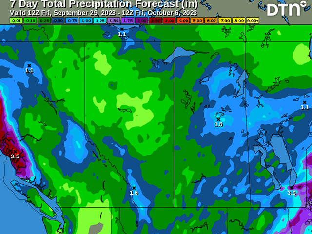
The next seven days looks like a good pattern in which to do so. A front is currently located across eastern areas of the region. A trough of low pressure is over the west. Both of those features will lead to scattered showers for the next couple of days. Though that trough digs down into the western United States this weekend, another will come through early-mid next week. A storm system will likely bring more scattered showers through the region. On the backside of the system, another disturbance will pass through and possibly bring additional showers. This one will occur in some colder air which could make for cold rain or a mix of snow. Snowfall accumulations are unlikely and would mostly melt on contact or after sunrise.
When all is said and done, through Oct. 6, precipitation amounts across the region will average between 10 and 20 millimeters (about 0.40 to 0.80 inches). Some lucky areas will pick up over 30 mm (about 1.20 inches) which would be scattered throughout the region and not favored in any one spot.
The rainfall will be nice, and widespread, but not nearly enough to significantly ease drought for the region. The rainfall does come on the heels of some rather decent rainfall during the last two weeks, particularly near the U.S. border where estimates of 10 to 20 mm fell in southern Alberta and Saskatchewan and amounts of 15 to 30 mm (about 0.6 to 1.2 inches) fell in southern Manitoba.
The drought monitor that will update in the next week or two will likely show some areas of improvement there in southern Manitoba at least, and probably other areas of Saskatchewan. We shall see. But the soil recharge season is upon us and the forecast at least in the short term is a favorable one.
To find more international weather conditions and your local forecast from DTN, head over to https://www.dtnpf.com/…
John Baranick can be reached at john.baranick@dtn.com
(c) Copyright 2023 DTN, LLC. All rights reserved.

Comments
To comment, please Log In or Join our Community .