

Ag Weather Forum
Heat Breaking Up, But Will Return in September

A heat wave may be on its way out later this week and weekend, but the Central United States isn't done with the above-normal temperatures yet. A return of some heat in September appears likely, though in absolute terms, temperatures will not be as extreme as they are this week.
It has been an absolutely miserable week of heat and humidity for a good portion of the Central U.S. so far. As of Aug. 23, we are in the midst of the most extreme and expansive stretch of the heat wave, with widespread temperatures in the 90s Fahrenheit between the Rockies and Appalachians, with many areas in the eastern Plains to the western Midwest and across the Gulf Coast hitting the century mark. To make matters worse, overnight lows have been hovering around 80 F and humidity levels have been horrendous for both plants and animals. Many daily temperature records are being broken on both the high and low side (record-high low temperatures) of the daily temperature curve, capping off the 2023 growing season with poor conditions after several weeks of recovery from a poor start to the season.
A front across the northern tier of the country has kept areas closer to the Canadian border, including the eastern Great Lakes, in more comfortable temperatures, at least when compared to their peers to the south, and that front will provide relief in the temperature department later this week and weekend.
A trough in the Pacific Northwest will move over the northern edge of the heat dome that has parked itself and intensified across the Central U.S. during the next couple of days, diving into the Eastern U.S. which will weaken the ridge and shift it back into the Rockies and Western states.
That will allow the cold front to dive south through the country and wipe out much of the scorching heat from Friday through the weekend. Daytime high temperatures will fall a good 15 to 20 degrees for most areas behind the front.
P[L1] D[0x0] M[300x250] OOP[F] ADUNIT[] T[]
Unfortunately, models don't suggest much precipitation. Usually, such a drastic drop in temperatures would bring relieving rainfall, but that does not look to be in the cards for too many locations.
There are some outliers through. The eastern Great Lakes states and isolated spots of the rest of the Corn Belt could pick up some decent rainfall with thunderstorms moving through. The Central Plains will also be watched for increased rainfall if the front can pick up the remnants of Tropical Storm Harold that will move into the Central Rockies on Friday. Otherwise, the heat from this week has sapped the soil moisture out of most of the primary growing areas in the country this week and the end of the 2023 growing season is shaping up like its beginning, with dry soils.
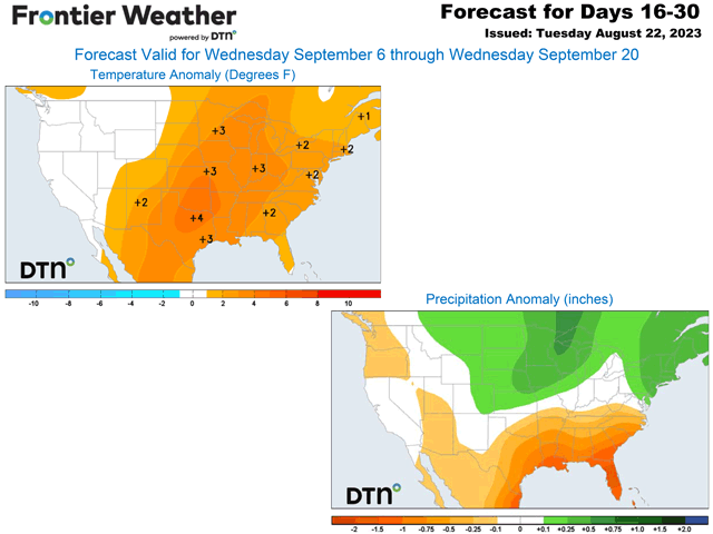
The break from the heat will last about a week. Lower temperatures underneath that trough will be pleasant, but that ridge in the West and Rockies will linger. Eventually that will shift eastward. Long-range models of the American GFS and European ECMWF models suggest that the ridge starts to shift eastward again as the calendar flips over to September. It may not be as expansive or strong as the current version of it is, but above-normal temperatures will come flooding east of the Rockies yet again.
According to DTN Long Range Weather Risk Analyst Nathan Hamblin, forcing in the tropical Pacific Ocean is largely to blame for this. "There is fair agreement that the MJO [Madden-Julien Oscillation] should push into phase seven during the week (starting Sept. 5). Analogs from past events suggest that ridging will nudge closer to the East Coast during that time. This means that above-normal temperatures will be likely for areas in the eastern half of the U.S. The South-Central U.S. may lead the way," he said.
Hamblin noted that the MJO signal also lasts through mid-to-late September. The MJO is expressed by a cluster of upward motion and thunderstorms that circle the equator. Depending on its location, it can have a strong influence on global weather patterns. El Nino is tied to this in some ways as well, but is more of a background feature, while the MJO moves around more frequently. Phase seven is in the western Pacific Ocean and acts more like background La Nina conditions than El Nino during the Northern Hemisphere summer.
While this past heat wave has been extremely intense and record-breaking, the upcoming one may not be as severe. September is a transitional month as we go from summer to winter and normal high and low temperatures fall rather quickly. Anomalies therefore may not paint the whole picture with regard to the return of the heat. But it does not mean that immature plants will look forward to it. They still need moisture.
In that regard, Hamblin is a little more optimistic than most models. "Above-normal rainfall will be likely across the North-Central and Northeast U.S. and this could be a limiting factor on high temperatures at times. Stronger thunderstorms could be a risk across the North-Central U.S. if a strong enough trough can set up in the West," he noted.
Models are less optimistic and show near-to-below-normal rainfall patterns during this time. Southern areas may not be as lucky as both the models and DTN suggest below-normal rainfall. The tropics could throw a wrench in that, however. We are coming upon the peak in the Atlantic tropical season. Hamblin said the risks are legitimate. "Any storms that can get underneath the trough (off the East Coast) may be able to reach Florida or even the Gulf of Mexico as they would be steered under the Eastern U.S. ridge. We will have to monitor the Gulf of Mexico for any close-in development."
Headed to the Farm Progress Show in Decatur, Illinois next week? Stop by the DTN booth and come say "Hi"! DTN Lead Analyst Todd Hultman and I will provide updates to longer-range market and weather outlooks at 10 a.m. CDT Aug. 29-31, and 2 p.m. Aug. 30-31.
To find more weather conditions and your local forecast from DTN, head over to https://www.dtnpf.com/…
John Baranick can be reached at john.baranick@dtn.com
(c) Copyright 2023 DTN, LLC. All rights reserved.
Comments
To comment, please Log In or Join our Community .