

Ag Weather Forum
Rain Starting to Disrupt Harvest in Canadian Prairies

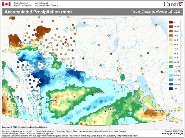
Areas of scattered showers moved through much of the Canadian Prairies during the last week. A couple of systems, fronts, and a visit from the remnants of what was Hurricane Hilary added up to streaks of rain across the region.
The heaviest amounts were in the northern portions of Alberta, an area that has been gifted with good rainfall most of the summer. Amounts of 20 to 60 millimeters (0.79 to 2.36 inches) were common in this area, with several locations picking up over 75 mm (about 3 inches).
Another nice streak went through some of the highest drought areas in the southwest with 15 to 30 mm (0.60 to 1.18 inches) from far southern Alberta through central Saskatchewan. Some locally heavier amounts were found in there as well.
A similarly moderate burst of rain was recorded along the North Dakota border of up to 25 mm (about 1 inch).
P[L1] D[0x0] M[300x250] OOP[F] ADUNIT[] T[]
Not all areas were that lucky, however. A relative lack of appreciable rain was noted east of Calgary into west-central Saskatchewan and across a good portion of eastern Manitoba.
Rain has only recently decided to pick up over the bulk of the Prairies. Drought has been especially deep in southern Alberta and southwestern Saskatchewan for the majority of the growing season. High temperatures well into the 30s Celsius (upper 80s to middle 90s Fahrenheit) have been a common occurrence in this part of the region as well, leading to poor crop conditions and damage. The rainfall now is coming too late to help most small grains and oilseeds and is instead having a negative influence on crop quality and harvest.
Read more about how Alberta and Saskatchewan's provincial governments are aiding producers from DTN Ag Policy Editor Chris Clayton here: https://www.dtnpf.com/….
The harvest in Manitoba sits at 13% complete as of Aug. 22, on par with the five-year average. However, the provincial crop report noted that the rains had not yet come to the region over the previous week. Rains there just started to show up during the past couple of days. Heavy rain in the southwest and moderate showers farther north will likely lead to some delays to further combining efforts.
Saskatchewan's harvest pace is ahead of schedule at 21% complete compared to the five-year average of 14% as of Aug. 21. Rains were more scattered during the last week, which helped to reduce the overall effect of the disruption, but there were reports of localized flood damage in some of the heavier bursts.
Alberta's crop report does not come out until tomorrow, Aug. 25, but is sure to show that drought has had a major impact on crop conditions. As of Aug. 8, the latest available report, good-to-excellent ratings were at just 43%, well under the five-year average of 58%. The Southern and Central districts, which have been hardest hit by this year's drought, sit at only 23% and 36%, respectively. Soil moisture in these two districts were rated at 93% and 70% poor-to-fair, respectively. Until this week's rain, that likely worsened as well. Harvest progress was not included in the latest report.
The forecast is a little bit drier going into next week. A system is bringing showers to far northern areas Aug. 24 and may have some light showers in Manitoba for Aug. 25. A front may provide a few showers to Manitoba again Aug. 27. But most areas are going to stay dry through Aug. 29, which may help combining progress. There appears to be another storm chance Aug. 30 to Sept. 1, however, which may produce more widespread rainfall again. Those that must wait until late next week may have to wait longer to get out into their fields.
But the rain isn't all bad, of course. Many areas have been waiting a long time for some significant rainfall. Some eastern areas that grow corn and soybeans could find a few finishing rains that may help out. And rainfall will be favorable to those with forages, pastures, and livestock for filling ponds and reservoirs.
To find more international weather conditions and your local forecast from DTN, head over to https://www.dtnpf.com/…
John Baranick can be reached at john.baranick@dtn.com
(c) Copyright 2023 DTN, LLC. All rights reserved.
Comments
To comment, please Log In or Join our Community .