

Ag Weather Forum
Record August Heat Threatens Crops and Livestock
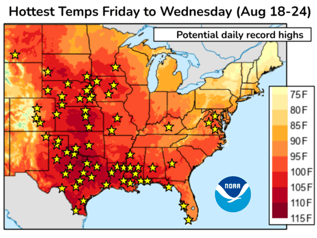
A powerful heat-producing high-pressure dome in the central United States during the third full week of August brings yield risk to crops and a safety threat to livestock and people. NOAA's Climate Prediction Center (CPC) noted in a bulletin on Aug. 18 that "Some locations in the Midwest may see their hottest day of the year so far this weekend, and portions of the South Central U.S. and Gulf Coast may further extend their record number of hours with a heat index reading of at least 110 degrees Fahrenheit." The CPC bulletin also called for many daily high temperature records, "especially in the Central Plains and Texas." Weekend reports supported that comment; Manhattan Kansas posted a contiguous U.S. high on Aug. 19 of 115 F.
Heat is forecast to continue through Thursday with excessive heat warnings across the central and southeastern Plains through the western, central and southeastern Midwest. The National Weather Service forecast office in Des Moines, Iowa noted in a comment on the evening of Aug. 20 that "the current record max temperatures at Des Moines stands at 99 degrees in 1975, and Waterloo at 99 degrees in 1948 for August 23 ... whereas the current forecast has both sites topping out around 103 degrees for this same day."
Hotter conditions over the central U.S. are not a surprise; sustained heat over the Gulf Coast and Southeast was expected to move north into the central states during this period. But the formation of former Tropical Storm Hilary in the eastern Pacific Ocean enhanced the intensity of this event.
P[L1] D[0x0] M[300x250] OOP[F] ADUNIT[] T[]
"Hilary is definitely playing a role building the intensity of the (central U.S.) heat ridge," said Nathan Hamblin, DTN weather risk communicator. "Without Hilary, there would still be an anomalous ridge, but Hilary added more of a meridional (north-south) component to the flow, which allowed for a further strengthening of the ridge."
Besides the actual air temperature, dangerous heat index values are in store. USDA Midwest Climate Hub Director Dennis Todey said in an email that drying of ground in areas which recently received rain, along with plant evapotranspiration (ET), will be significant and contribute to the heat index threat. "With the (heat-producing) ridge parked on us, there is limited mixing for the moisture in the atmosphere," Todey noted. "So, you have sinking air ... increasing temperatures and then moisture from the surface that is also trapped under the ridge. Perfect set-up for high heat index episodes. And if crops are still in decent shape they are going to try to increase ET to cool as much as they can adding more moisture to the system."
Livestock are also in peril from this stressful heat and the heat index potential. "Producers don't have many options with this high a situation. Watering to cool doesn't do much and can actually make the situation worse by increasing the dew point around the livestock," Todey said.
This intense heat is expected to ease by the weekend of Aug. 25-27. But its effect on crop yield may not be known for months until all harvest results are recorded. In addition, this searing heat sets a definite hot/mild/hot structure to the central U.S. row crop weather story of 2023.
Bryce Anderson can be reached at Bryce.Anderson@dtn.com
Follow him on X, formerly known as Twitter, @BAndersonDTN
(c) Copyright 2023 DTN, LLC. All rights reserved.


Comments
To comment, please Log In or Join our Community .