

Ag Weather Forum
Possible Derecho Moving Through Gulf States Wednesday
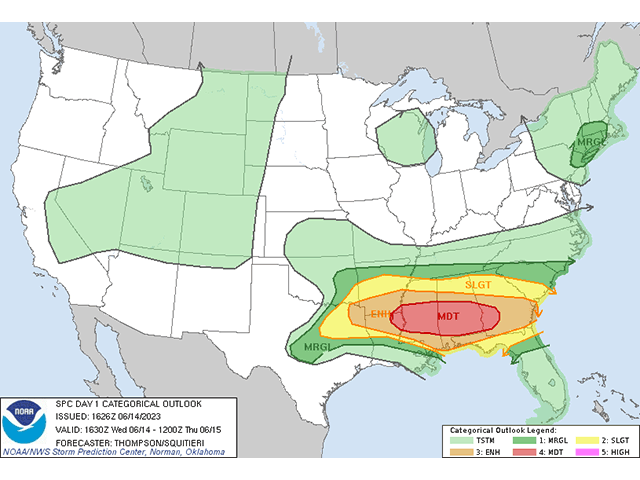
Several clusters of strong and severe thunderstorms have been developing this morning from Texas and Oklahoma to Georgia. With increasing heat and winds, storms are becoming more numerous and showing potential for turning into a derecho. The Storm Prediction Center (SPC) has outlined a moderate risk of severe weather in this region, which includes the risk of developing derechos.
According to the National Weather Service, a derecho is defined as a sustained severe windstorm produced by strong thunderstorms that have continuous severe wind gusts over 58 miles per hour with several over 74 mph (hurricane strength) and last for more than 240 miles.
P[L1] D[0x0] M[300x250] OOP[F] ADUNIT[] T[]
As of 12:30 p.m. Central Daylight Time, a particular storm of interest is located over northeast Texas that will ride along the Arkansas-Lousiana border area through the afternoon hours. The SPC has a mesoscale discussion regarding their concern that this cluster could become a derecho. You can find more information about that here: https://www.spc.noaa.gov/….
However, any thunderstorm cluster may develop into a derecho this afternoon and evening and the region should be aware that although this particular storm is very concerning, others in the region are just as likely to produce severe damage.
Derechos may also produce tornadoes, hail, and flooding, of which any thunderstorm cluster that develops in this area may produce.
To find updated radar and analysis from DTN, head over to https://www.dtnpf.com/…
John Baranick can be reached at john.baranick@dtn.com
(c) Copyright 2023 DTN, LLC. All rights reserved.

Comments
To comment, please Log In or Join our Community .