

Ag Weather Forum
Drought Increases for Alberta, Mixed Elsewhere for Prairies in May
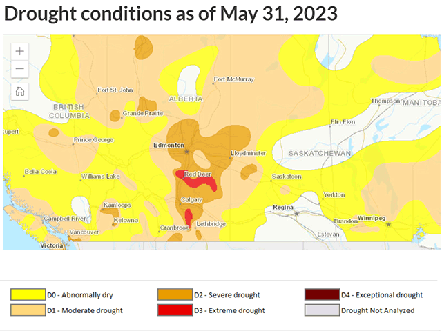
The Canadian Drought Monitor updated on June 9 for the month of May and brought significant degradation of drought across large portions of central and southern Alberta. From Edmonton southward, drought degraded at least one class for most areas. South of Calgary, it was largely two classes of degradation. Soil moisture in the southern portion of the province has essentially dried up and crop conditions are falling due to heat and lack of moisture. As the Alberta Crop Report notes from June 9, "many crops are reliant on timely moisture for their daily moisture needs."
Across the rest of the Prairies region, rainfall was mixed for May. Northern Alberta got a heavy rainfall event that helped to fight the ongoing wildfires, but have since dried up. Parts of Saskatchewan and western Manitoba saw good rainfall as well, and drought improved there. But other parts of northeast Alberta, northwest Saskatchewan, and eastern Manitoba saw much less and drought worsened. Overall, it was a mixed bag with southern Alberta seeing the worst that May had to offer.
That comes during a very active pattern that has extended now into June. In fact, during the last two weeks, portions of far southern Alberta, northwest Saskatchewan, and eastern Manitoba that saw drought increasing in May, received some beneficial rainfall. Other areas of Saskatchewan and western Manitoba did as well. Central Alberta has not been as lucky in the recent pattern, with showers being spotty, weak, or absent during the last two weeks. But that is about to change.
P[L1] D[0x0] M[300x250] OOP[F] ADUNIT[] T[]
The pattern remains a very active one and an upper-level trough around Alaska will send a piece of its energy southward through British Columbia June 13-14. In response, a low-pressure center will form in Alberta later Tuesday, with showers increasing first over northern Alberta. But on Wednesday, the low will move to the northeast, dragging a cold front through the province while maintaining upslope flow into the Rockies.
The two factors should combine to produce areas of heavier rainfall into Thursday. Model forecasts are printing out the likelihood that 25 to 50 millimeters (1 to 2 inches) lands over the driest portions of central Alberta the next few days, with localized heavier amounts where thunderstorms occur.
Northern Alberta and the Peace region are also in line for similar amounts, though the southeast corner is not.
Parts of northwest Saskatchewan are likely to see some heavier amounts as well. As the system moves eastward to end the week, showers will become more isolated, with pockets of showers and thunderstorms expected for the rest of Saskatchewan and Alberta for Thursday and Friday. Of course, when dealing with thunderstorms, amounts are never uniform, so there will be some winners and losers in these areas, but overall, this is a good setup for increased precipitation in some of the driest places in Alberta.
Mother Nature won't be done with the region afterward either. The Alaska trough will make a big push south during the weekend, which is likely to produce another storm system in the western Prairies that would likely cause more bouts of heavy rain going into next week. It is uncertain how eastern areas of the region will fare, but no doubt areas of showers and thunderstorms will be around. More opportunity to decrease drought in the region is anticipated going into late June as well.
While drought has increased significantly in parts of the Canadian Prairies during May, the recent and forecast rainfall in June should help to undo some of the areas that saw increases, especially in Alberta. Whether or not it will be as widespread as forecast remains to be seen, however.
To find more international weather conditions and your local forecast from DTN, head over to https://www.dtnpf.com/…
John Baranick can be reached at john.baranick@dtn.com
(c) Copyright 2023 DTN, LLC. All rights reserved.

Comments
To comment, please Log In or Join our Community .