
Ag Weather Forum
Summer Weather Pattern on Hold as Active Spring Conditions Continue
The calendar has flipped over to June 1, the start of meteorological summer. Why June 1 instead of on the summer solstice on June 21? Because meteorologists like to keep things simple, and we can be lazy at times as well.
Starting on June 1 allows us to easily compare months instead of seasons, whose dates change by a couple of days and are not always noticeable when that transition occurs. Starting at the first of a new month "makes more sense" to us. This year, it might make more sense to transition near the solstice because the very active spring pattern we have been witnessing continues to assert its dominance on the pattern until then.
La Nina has certainly played its role this year, not allowing the summertime pattern to show up just yet. Its influence is waning, but does support active weather during the spring. In contrast, during the summer La Nina favors a ridge of high pressure over the middle of North America.
DTN is still forecasting that to happen, but for at least the next couple of weeks, the active pattern continues across North America. At times this active pattern has produced strong storm systems, and at other times more progressive small disturbances. We will see a combination of both during the next couple of weeks. But the results have been the same. It has been very wet in parts of the Northern Plains and eastern Canadian Prairies through the Corn Belt. It has also led to reduced drought across the driest areas of the Central and Southern Plains, though that has come only more recently, much to the lament of winter wheat producers from Kansas to West Texas.
Producers there are dealing with some of the poorest winter wheat conditions in decades. The rains farther north have made spring planting a difficult task. However, even small windows of opportunity have been taken advantage of and corn and soybean planting has caught up to the five-year average pace for most areas.
P[L1] D[0x0] M[300x250] OOP[F] ADUNIT[] T[]
That is not true in North Dakota and Minnesota. These two states had near- to above-normal snow cover during the winter, were pounded by two strong storm systems in April that produced blizzards and/or heavy rain, and have seen regular bouts of moderate to heavy rainfall since, limiting planting progress.
On the latest USDA Crop Progress report issued May 31, planting progress for every crop that is tracked in these two states is behind normal by at least 10 percentage points and for some crops, more than 30 percentage points.
From the primary crops of corn, soybeans, and spring wheat to the more minor ones of sugarbeets, oats, barley and sunflowers, everything is behind schedule. Flooding in and around the Red River Valley has been a predominant feature since the onset of the spring melting. And during the Memorial weekend, another couple of inches of rain were recorded for most of these areas. The active pattern may have a temporary reprieve here through the end of this week. But disturbances coming through the region may produce more showers this weekend through next week, giving producers only limited opportunities to see their fields dry out enough to get out and plant. The region may dodge a few of these disturbances, but likely not all of them. These producers are facing some difficult decisions regarding insurance and prevent planting.
Across the rest of the Corn Belt, there have been enough dry stretches for most folks to catch up, though they may be doing it at a cost of planting into suboptimal soil conditions and at a risk of mental health working long hours. Still, planting pace is back up to or exceeding the five-year average pace for these states and soil moisture is relatively high throughout the majority of the region. The crop that is already in the ground is in good shape overall with enough moisture for early growth.
That increased soil moisture has also extended south through portions of the Southern Plains, including drought areas in the west. A frontal boundary pushing south through June 2 is producing more rainfall as well, with heavy rain and some flooding concerns from West Texas up through western Missouri. The active pattern here will continue to produce areas of isolated to scattered showers going through next weekend at least. Although that will only come in spurts and may not hit everyone, it could yield more moisture for early summer crop growth in the drought areas.
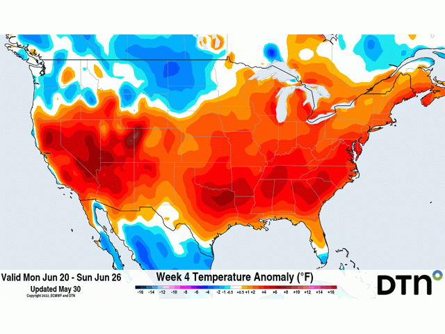
So, the question is, "When does the summer pattern start?" DTN has been forecasting a hot and dry summer for months. The La Nina conditions continuing in the Pacific Ocean have led to increased confidence in this occurring. Now that we're in June, when should we expect this pattern to change from our active spring to a doldrum-type summer?
Well, we might have to wait until July. There are some conflicting signals between some of the indicators we use as to when this flip will happen. And it may not be a strict flip to hot and dry like we saw in June 2021, it may be more gradual. We will start to see our summer ridge develop in the Southwest or Southern Plains late this month. That will put a hold on the active pattern across the southern half of the country, but we may remain a little active across the north going into July before that ridge takes over.
Still, the ridge does not mean that temperatures will be continuously 20 degrees above normal with absolutely no rainfall. That may be true over west Texas, but most of the country it will not. The northern extent of a ridge is typically an area that can be counted on to produce clusters of thunderstorms that "ride the ridge" going through the Canadian Prairies and northern U.S. through the Great Lakes and into the East Coast. Depending on where the edge of that ridge sets up, we could see more showers farther south as well.
But the timing of these storms should be fewer than what we have seen this spring. That produces risks for drought redeveloping where it has been alleviated this spring, getting worse in areas that remain in drought, or developing in areas that have not seen drought since last year or years prior. It remains a question of when, and for the northern U.S. and Canadian Prairies, it might be later than what we thought a few months ago. While planting has been slow, a longer wet period is a change from the previous forecast of hot and dry starting this month. However, our confidence is not high.
To find more regional weather conditions and your local forecast from DTN, head over to https://www.dtnpf.com/…
John Baranick can be reached at ohn.baranick@dtn.com
(c) Copyright 2022 DTN, LLC. All rights reserved.

Comments
To comment, please Log In or Join our Community .