
Ag Weather Forum
La Nina Brings Crop Yield Challenges and Hurricane Risk This Summer
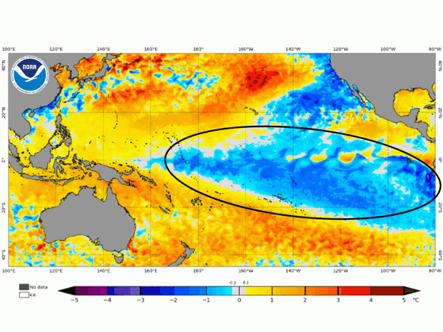
La Nina continues in the equatorial Pacific Ocean. Late-May analysis of sea surface temperatures indicates values of as much as 3 degrees Celsius or 5.4 degrees Fahrenheit below normal from the South American coast to the Marshall Islands in the central Pacific -- a distance of 7,600 miles. Along with that cool water, the barometric pressure detail measured by the Southern Oscillation Index (SOI), which tracks the comparison of atmospheric pressure between the island of Tahiti and Darwin, Australia, sports a 30-day moving average of plus 19.4 and a 90-day moving average of 16.7. Both values are solidly in the "moderate" category for La Nina barometric readings. University of Miami climate scientist Emily Becker noted in a blog post on the NOAA climate.gov website that "April 2022 was tied with 1950 for the strongest negative (cool) April anomaly in the 1950-present record."
This will be the third consecutive summer season with La Nina around for at least a portion of the season. Using NOAA's Oceanic Nino Index (ONI) criteria, La Nina showed up during the last half of the 2020 summer; loomed over the entire 2021 summer; and is projected to be in place for the entire 2022 summer. Climate agency forecasters also estimate a 61% chance for La Nina during next fall and early winter.
Mention La Nina to a commodity market analyst, and it's likely that the guess will be "below trendline" when summer crop yields are discussed. That's because some of the most subpar corn performance years coincide with La Nina. In the past 10 to 12 years, La Nina was in effect during the summer seasons in 2010 and 2011, and during the first five months of the year in 2012. Those years featured below-trendline corn yields, highlighted by a plunge to 123.4 bushels per acre in 2012. The Pacific Ocean moved into La Nina during the summer of 2020 as well, which resulted in a below-trendline corn yield due to damage from a huge Midwest derecho along with heat and dryness during the grain-fill phase in the central United States.
Adverse impact to corn yield performance is due to La Nina forcing a relocation of the jet stream northward during the summer season, thus reducing precipitation chances in the Midwest. This comes at a time when corn supplies are low; the U.S. corn ending stocks to use ratio is estimated at just over 9% through the end of the 2022-23 marketing year, down almost one-third from the average 14.4% stocks-to-use ratio in the five-year period from 2015-16 to 2019-20.
La Nina looms also as a contributor to a more active hurricane season, bringing a threat to southeastern U.S. agriculture. Forecasters at NOAA
P[L1] D[0x0] M[300x250] OOP[F] ADUNIT[] T[]
announced a 70% confidence factor of 14 to 21 named tropical storms (winds of 39 miles per hour or higher); 6 to 10 storms reaching hurricane category (winds of 74 mph or higher; and 3 to 6 major hurricanes (category 3, 4 or 5 with winds of 111 mph or higher) for the 2022 hurricane season.
On May 30, the first hurricane of the season -- Hurricane Agatha -- made landfall near Puerto Angel, Mexico, and was a strong Category 2. At maximum sustained winds of 105 mph (165 kilometers per hour), the hurricane was the strongest hurricane on record to make landfall in May in the eastern Pacific.
A seventh straight hurricane season with above-average activity is predicted. One of the primary reasons for this forecast is the influence of La Nina. As noted by climate scientist Emily Becker in a post on the NOAA Climate.gov website: "La Nina conditions decrease the vertical wind shear -- the difference between near-surface and upper-level winds -- over the tropical Atlantic. Shear makes it harder for hurricanes to develop, so La Nina's reduced shear can contribute to a more active hurricane season."
In summary, La Nina's presence and influence contribute to some significant concerns about summer weather across the U.S., both inside and outside agriculture.
The NOAA ENSO blog is available here: https://www.climate.gov/…
The full NOAA Hurricane Forecast announcement is available here:
La Nina already contributed to an extreme spring season:
Bryce Anderson can be reached at Bryce.anderson@dtn.com
Follow him on Twitter @BAndersonDTN
(c) Copyright 2022 DTN, LLC. All rights reserved.

Comments
To comment, please Log In or Join our Community .