

Ag Weather Forum
Higher Temperatures Spreading Through Central US for Rest of June as High Pressure Ridge Builds
The heat is coming. It has only been a matter of time. Mother Nature has blessed many areas this spring with some active weather, good rainfall, and drought reduction in spots, but she may just be teasing with many producers' hopes for a fantastic growing season. The active weather pattern from the spring has extended itself into early summer, but how long will this continue?
Last week, I wrote about some mixed signals we were seeing on when this pattern would change. You can view that here: https://www.dtnpf.com/….
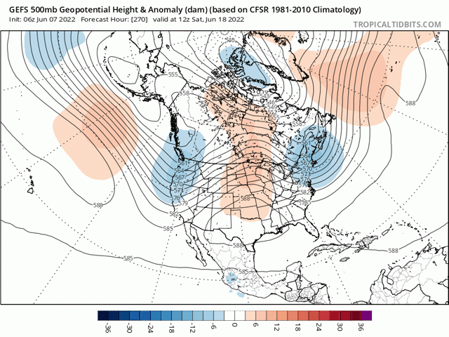
With another week under our belt and a little more consistency in the models, it looks like that ridge will start developing late next week, building a firm ridge across the middle of the country by June 18. A trough will then set up in Western Canada and the Pacific Northwest, perhaps just offshore. Both features will be important to the weather pattern going forward, with potential for active weather for an extended period in the northwestern Plains and Canadian Prairies.
But that is not the be-all and end-all of a consistently hot and dry pattern for the middle of the country that has been forecast for months. There are still some questions in this pattern. One has to do with the strength of this ridge. Between the American GEFS, European and Canadian models, this has been the main question.
P[L1] D[0x0] M[300x250] OOP[F] ADUNIT[] T[]
A stronger ridge would imply hotter and drier conditions across the middle of the country, and likely farther north as well. A weaker one would allow more disturbances to flow over the top of the ridge through the North-Central United States to the Northeast, keeping the region active with plenty of moisture and suppressing the heat. Models are implying that the strength of the ridge should increase with time for late June into July, pushing the active weather pattern gradually northward as we get toward Independence Day.
But there are other questions to the pattern, including how strong the trough will be in the West. If stronger pieces of energy move through, this could take some bite out of the ridge, leading to more active weather and lower temperatures again across the Canadian Prairies, North-Central U.S., all the way through the Northeast. Weaker ones may not make for such an active situation in these areas and allow the ridge to strengthen further.
Both are questions that models still need to answer that leaves confidence about the Corn Belt and Canadian Prairies weather a bit lower than normal for this extended range. But we can reasonably say with good certainty that the heat and dryness are coming to more of the Southern Plains and Delta regions and quite possibly the Southeast as well.
This spring has been an active one for these areas, and drought has been declining for the last few months, if only in spots. That might just be a temporary situation, however. The heat and dryness that are building in Texas and the Southwest will spread throughout these areas for the rest of June. That could quickly reverse the benefits that have been seen, especially for those areas that still remain in drought in the southwestern Plains.
Those hot and dry conditions expanding northward are expected to lead to more drought development with time over the summer. But guessing exactly where is just that, a guess. Given the recent soil moisture and proclivity of thunderstorm complexes to miss certain areas completely and hit others repeatedly, even in a dry pattern, drought could pop up just about anywhere ... or not. Underneath the ridge from Nebraska and Iowa up through Manitoba stand the best chance for this to occur. But if flash drought were to occur in Michigan, Kentucky or along the Mid-Atlantic, we should not be surprised.
Until then, the continued active pattern will be very important. Good soil moisture through early growth sets up crops with higher maximum yield potential. The dryness at the end of the season would be unfortunate and take the bin-busting potential out of the crop, but allows the potential to get just enough rain at just the right time to produce good yields. All hope is not lost.
To find more regional weather conditions and your local forecast from DTN, head over to https://www.dtnpf.com/…
John Baranick can be reached at john.baranick@dtn.com
(c) Copyright 2022 DTN, LLC. All rights reserved.
Comments
To comment, please Log In or Join our Community .