Ag Weather Forum
Here's Why Winds Have Been So Strong: La Nina and Friends
It seems like everyone in the central United States is talking about the winds this spring. Day after day, wind speeds of at least 30 miles per hour (and often stronger) have been dominant. In the U.S. Southern Plains, the winds have combined with bone-dry conditions to drive devastating wildfires and choke winter wheat and pastures. In the U.S. Northern Plains, the winds along with snow produced blizzard conditions with safety hazards, health risk to livestock and extensive delays to spring planting. In addition, the tempestuous winds have eroded soils and have literally blown away tangible amounts of high-priced fertilizer.
Wind velocities have indeed been off the charts. USDA's weekly weather and crop bulletin has this excerpt of extreme velocities during the week of April 18-24: "High winds -- some related to severe thunderstorms -- battered the Plains and Southwest. On April 22, the Plains' peak day for severe weather, wind gusts in western Nebraska were clocked to 83 mph in Scottsbluff and 76 mph in Sidney. The following day, non-thunderstorms winds reached 76 mph in Douglas, Wyoming, and 66 mph in Chadron, Nebraska. On the Texas High Plains, peak gusts April 22 were clocked to 73 mph in Lubbock and Dalhart. Similar gusts were reported on the 22nd in New Mexico -- 70, 72, 73, and 80 mph, respectively, in Gallup, Farmington, Las Vegas, and Raton."
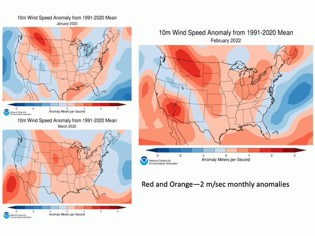
When it comes to wind climatology "We don't have a real extensive data set," said USDA Midwest Climate Hub director Dennis Todey. However, average wind speeds on a monthly basis offer some perspective. "During January, February and March, the wind speeds in the U.S. Plains were stronger than average by as much as two meters per second -- or about 4.5 miles per hour. That is a significant departure from average," Todey said. Similar departures above average or even greater are possible when the April reports are compiled.
P[L1] D[0x0] M[300x250] OOP[F] ADUNIT[] T[]
Winds of this magnitude and extent have several macro-scale causes. In this case, there are: the continued influence of La Nina in the equatorial Pacific; the ongoing presence of persistent upper-atmosphere high pressure in the northern latitudes; and the contribution of drought in the Southern Plains and western U.S.
La Nina is the term used to identify a large-scale sustained cooling of the Pacific Ocean equatorial waters. 2022 will be the third consecutive year of La Nina, and this iteration is analyzed as a moderate-strength event. One of its effects is that La Nina tends to set up the continental North America storm track over the northern U.S. This is especially evident during winter and then shows some moderation going into spring, when a typically warmer trend moves the jet stream northward.
This year, however, that northward migration of the jet stream has been blocked -- stalled--by high pressure centered over the Gulf of Alaska. As a result, storm systems that form in the northeast Pacific have consistently tracked across the northern U.S. The large differences in temperature and air pressure from north to south have ramped up the strong winds as nature tries to balance the pressure differences out. These elements, and the resulting strong winds, have remained stuck in place all month.
Widespread drought in the Southern Plains and the western U.S. -- also influenced by La Nina -- has added to the extreme wind conditions. Christopher (Chip) Redmond, Kansas State University assistant meteorologist and weather data library/Mesonet manager, outlined several ways that drought contributes to extreme winds in an email to DTN.
"Dry air tends to result in a greater diurnal (night to day) fluctuation. This results in greater terrain flows and breezier winds," Redmond said. "Dry air and parched soil surface also allows warmer afternoon temperatures (especially as we see increasing solar input later in the spring). Warmer temperatures allow for high mixing heights, thus mixing down stronger winds. And drought upstream from Kansas results in drier air aloft. This leads to clearer skies and thus, warmer surface temperatures yielding higher mixing heights and strong winds aloft mixing down."
The northern blocking high is forecast to remain in place through the first half of May. It is then forecast to weaken and allow for upper air systems to move across North America. Periods of strong winds are still likely, however, due to storm formation during late spring. La Nina is on track to continue its influence through the balance of the spring and summer in the latest forecasts.
Bryce Anderson can be reached at Bryce.anderson@dtn.com
Follow him on Twitter @BAndersonDTN
(c) Copyright 2022 DTN, LLC. All rights reserved.


Comments
To comment, please Log In or Join our Community .