Ag Weather Forum
Planting Weather is a Challenge Across US This Week
Planting progress has already been slow this spring. All three major crops -- corn, soybeans and spring wheat -- are behind schedule. Typically, early May is when planting really gets underway and progress jumps. But you need to be able to get out into the field to realize that progress. Wet fields, even if there is not significant ponding, will cause producers to wait. And the forecast for this week suggests that much of the country will continue to do just that.
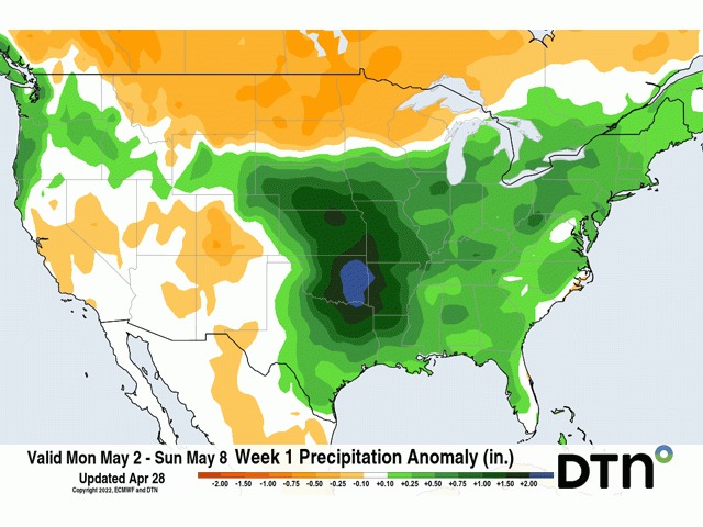
Soil moisture is already pretty high in the Dakotas and the rest of the country east of the Plains, the Mid-Atlantic notwithstanding. A storm system moved out of the Rockies and into the southeast Colorado on the morning of May 2. That system produced some strong thunderstorms in west Texas on May 1 and has developed widespread precipitation from Nebraska into Arkansas for the morning of May 2. That system will continue to expand and produce rainfall as it moves northeast through the Midwest through May 3. Severe weather is expected to occur across Oklahoma and southeast Kansas on May 2, with the severe threat along the Ohio River for May 3.
But that is not the only system of the week. Another one moving into the Pacific Northwest on May 2 will follow a similar path as the first one this week, albeit a bit slower. Showers and thunderstorms will again develop across the Central and Southern Plains May 4, then move through the Midwest May 5-7. More moderate to heavy rain is expected, along with bouts of more severe weather.
Both systems will also bring some occasional rains to the Delta and Southeast.
P[L1] D[0x0] M[300x250] OOP[F] ADUNIT[] T[]
All-in-all, precipitation will be heavy and widespread enough to keep producers out of their fields with only limited areas lucking out and being able to get some work done.
The Northern Plains and most of Minnesota will be much drier this week, as those systems miss to the south. However, with ample precipitation for much of the region during the last two weeks, soils still need to drain before producers can get out on a large scale. They may risk getting out into non-ideal conditions to plant anyway, as the forecast for the weekend into next week is shaping up to again provide abundant opportunities for additional showers.
This spring is shaping up to be a difficult one for producers to get out and get work done, but there is a silver lining that may shape how the rest of the season goes as well. The active weather has either maintained or increased soil moisture across much of the Northern Plains and areas east of the Plains. There are few areas outside of the corridor from Nebraska to Texas that are unhappy with the availability of moisture for their crops to start off the season.
Precipitation this week will help those drier areas out at least partially. Drought remains a large concern. And the spotty nature of showers this week in hard red winter wheat areas will leave few happy and others lamenting the pattern. But this pattern is providing the best coverage and amounts of rainfall this region has seen since mid-March. Corn and soybean areas in Nebraska and Kansas will be much better off than a week prior.
The forecast for the summer months continues to be hot and dry for almost the entire area between the Rockies and the Appalachians. Drought is expected to be maintained or worsen in the Plains, while spotty flash droughts develop to the east. The rainfall that has occurred, and is coming, this spring can lessen the blow of drought by giving crops a good head start at building roots and yield potential.
I feel that producers would rather have it the other way around, with a drier spring and wetter summer, but getting adequate to abundant precipitation to start off the year may limit the potential losses later on in the season to some degree. It may be difficult to plant, but crops should start on a relatively good footing for much of the country's growing regions when the seeds do get into the ground.
To find more regional weather conditions and your local forecast from DTN, head over to https://www.dtnpf.com/…
John Baranick can be reached at john.baranick@dtn.com
(c) Copyright 2022 DTN, LLC. All rights reserved.


Comments
To comment, please Log In or Join our Community .