

Ag Weather Forum
May 2022 Weather Outlook Suggests Late-Planting Risks
April 2022 has been an abysmal month if you are trying to go out and plant your crop for most of the United States. It has also been a terrible month for drought in the southwestern Plains, as the active pattern elsewhere has essentially bypassed the region going back to fall 2021. Will May 2022 be any better? Find out below.
For April, the pattern has been to keep areas east of the Mississippi River quite wet with limited exceptions, a continuation since last year. However, April also added on extreme amounts of moisture into the Northern Plains and eastern Canadian Prairies. Some areas of North Dakota have seen over 4 inches of liquid equivalent of rain and melted snow. For example, Minot, North Dakota, averages just 1 inch of precipitation in the month of April. The 5.67 inches recorded through April 25 is well enough above normal to lift the region out of significant drought. We await the update on the drought monitor that will be released on April 28, but we expect to see significant improvements from eastern Montana, northeast Wyoming, through the western Dakotas.
While many in the region are quite happy to see the increased precipitation, the low temperatures that turned a lot of it into snow has been unfavorable and lengthened the time that the moisture soaks in or runs off, creating further delays for spring wheat planting. Last year, the Northern Plains were well ahead of schedule for spring wheat planting. This year, they are behind. And, with more moisture coming up, those delays look to be extended.
The far eastern Plains and points eastward have also had more than their fair share of moisture in April. Soggy grounds have limited planting for both corn and soybeans, which are also behind. The only states to be at or ahead of their five-year averages in corn and soybean planting are across Southern and Plains states. States like North Carolina, Texas and Kansas, which have had more limited moisture during the month, are on schedule for corn. For soybeans, it is still early. But the main production "I" states of Illinois, Indiana and Iowa have barely started planting either crop yet. You can find more information about the situation in this part of the country here: https://www.dtnpf.com/….
Blaming wet and cold soils is easy and correct. USDA noted that topsoil moisture is running strong surpluses along and east of the Mississippi River. Rains have been coming every few days, keeping soils from drying out enough to get equipment into the fields to do much of anything.
P[L1] D[0x0] M[300x250] OOP[F] ADUNIT[] T[]
So how does May look? Well, for the first half of the month, it looks like more of the same. According to DTN Long-Range Team Lead Nathan Hamblin, the progressive storm pattern will continue for the next couple of weeks. Hamblin mentioned that thunderstorm clusters that move around the globe near the equator are partly to blame for both the active weather and the lower temperatures at least across northern areas through mid-May. The other culprit is high-latitude blocking across northern Canada. DTN Ag Meteorologist Emeritus Bryce Anderson talked about that in his blog here: https://www.dtnpf.com/….
The progressive thunderstorms keep the pattern moving, not allowing upper-level high-pressure systems to get entrenched around the U.S. The high-latitude blocking across Canada keeps that storm track moving through the U.S. and provides cold weather to Canada and the north-central U.S. that fuels stronger storm systems that can produce heavier and more widespread precipitation. Hamblin feels that that pattern will not change for the next two weeks.
"However," he noted, "thunderstorms will tend to favor a progressive pattern into the 'Maritime Continent' region for the late half of May."
The Maritime Continent region is the region of islands in the Pacific between southeast Asia and Australia. It is not quite a continent and not quite free-flowing ocean, hence the combination of both in the name.
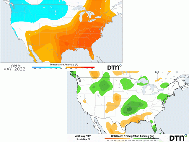
When thunderstorms favor developing in this region this time of year, it sets up North America generally with warmer weather across the eastern half of the continent and colder conditions across the west. Due to the abundance of soil moisture across much of the country, that may not reveal itself as warmer high temperatures, but warmer low temperatures, leading to reduced frost risks later in the month.
Higher air temperatures will help soils to drain through increased evapotranspiration. That targets much of the Plains, Midwest, and points eastward with warm weather conditions. But the pattern also favors colder conditions in the western half of North America that also leaks into the Canadian Prairies and Northern Plains. That is not a good situation if you are trying to plant or worry about frost affecting your young plants.
The other impact of this pattern will be to shift the storm track from right through the U.S. to more of a Northern Plains through central Canada track. That will keep wetter weather in play for the Canadian Prairies and Northern Plains. But also across much of the country as well. Cold fronts to storm systems would have a tendency to hang up across the southeastern Plains through the Ohio Valley instead of push all the way through like we have seen recently. Those fronts could lead to some heftier rainfall events for a lot of areas. Those that would be more likely to be left out of the increased precipitation hazards would be the southwestern Plains, including much of the hard red winter wheat territory already facing incredible drought, and the Southeast, which could lead to more drought developing for pastures and cotton.
Overall, the effects of the expected pattern for May suggest that planting windows will continue to be tight. That was forecast for the Eastern Corn Belt several months ago, but now includes the Northern Plains as well with the lower temperatures and recent and forecast heavy precipitation.
Planting delays will continue, and the prospect of significant June plantings is increasing. The tendency should also be to see drought continuing to play a major role in winter wheat development through the month across the southwestern Plains. While some showers will still develop, and those may be more likely to be strong to severe, overall amounts are likely to be below normal region-wide. The effects for early corn and soybean development in these areas is also likely to be limited with increased reliance on irrigation.
Of course, the summer forecast has not changed. Hot and dry conditions are likely for much of the country's primary growing regions, with drought worsening in the Plains and spotty development to the east weighing on production this season.
To find more regional weather conditions and your local forecast from DTN, head over to https://www.dtnpf.com/….
John Baranick can be reached at john.baranick@dtn.com
(c) Copyright 2022 DTN, LLC. All rights reserved.

Comments
To comment, please Log In or Join our Community .