
Ag Weather Forum
All Aboard the Clipper Train

Most of North America enjoyed a warmer stretch of weather last week as we said goodbye to the cold, arctic air for at least a little while. But it is still winter, so when will our next cold shot come through and will it be a long-duration event?
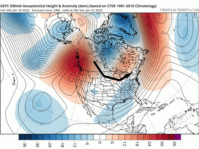
Again, we look to the upper levels to see what is headed our way in North America for the next 10 days. What we are going to see is a relatively stable setup. The ridge of high pressure that brought in the warmer weather last week has shifted off to the West Coast and up into Alaska. Meanwhile, an upper-level low is forming over Hudson Bay. Those features are not going to change much through almost the end of January and will set up a storm track perfect for creating Alberta clipper systems.
Clippers have a tendency to develop around Alberta, Saskatchewan, or sometimes the Northern U.S. Plains and move through the U.S. Corn Belt around the base of the trough in Hudson Bay. Usually, we see some potent low-pressure centers which create some briefly strong winds and pull down some cold, arctic air from northern Canada or sometimes around the North Pole. They are usually associated with light precipitation because the systems move quickly and are coming from Canada, not a huge source of moisture. But their intensity sometimes causes a band of moderate to heavy snow on the northern side of its track, especially if it can pick up a little bit of moisture from the Gulf of Mexico as it works across the Midwest.
Not all clippers are the same. They vary in intensity, track, duration, and speed and cause sometimes wildly different outcomes even though the setup is very similar. The series of clippers set to move through North America in the coming days will be no different.
P[L1] D[0x0] M[300x250] OOP[F] ADUNIT[] T[]
One has already started moving across the U.S. Canada border since Jan. 17 and will continue in that fashion through Jan. 19 before moving into the Canadian Maritimes. The heaviest snowfall has been and will be on the Canada side of the border, but as the front to the system moves south of the Ohio River, it will pick up moisture from the Gulf of Mexico and produce more moderate to heavy rain as the front sags through the rest of the U.S. If the front can hang up near the Gulf Coast instead of spreading through it, then we could see another round of wintry precipitation for the Southeast and Mid-Atlantic U.S. on Friday and Saturday.
Colder air follows behind the front, putting an end to our warmer pattern. Each clipper that moves through will do something similar, bringing down colder air for a short period. The cold will be more focused across central Canada into the Midwest, away from the Rockies. The cold will be briefer and more muted in that area. Some snowfall events will be stronger than others.
Impacts from clipper systems are notorious for being poorly handled by models until roughly 48 hours before the event. So, it is hard to really forecast if these systems will have bands of moderate snow or where they will occur. The track is usually the hardest to pick out. And that is what causes a lot of folks to become angry at weather forecasters. When you look at a forecast and see 6-inch (15-centimeter) totals for your area, but receive next to nothing because the track shifted 50 miles (80 kilometers), it is perfectly reasonable to question the forecaster's ability. I know these sorts of systems give me anxiety when I forecast them for that same reason.
And there will be several that track from the Canadian Prairies through the Corn Belt during the next 10 days. One in particular looks more potent than the rest. That one will move through the Canadian Prairies Jan. 23 and through the Corn Belt Jan 24. Models are intent on putting down a band of moderate snow with it. But again, I have a hard time describing the areas most likely to see it due to the track of the system being questionable this far out.
What is most likely though, is as these fronts from the systems move through the Central and Southern U.S. Plains, that they will have very little moisture with them. Drought that has been increasing for winter wheat areas will continue to grow. Every time that models indicate a chance for precipitation for the region, the results have been light precipitation or nothing. That does not bode well for the 2022 winter wheat season to continue building drought. But if there is any time to build drought, it is during the winter when plants are not actively growing.
That places a larger importance on spring precipitation. If the spring rains are lacking as well, then the wheat crop is not going to do so well. Unfortunately, long-range forecasts continue to call for below-normal precipitation in the Central and Southern Plains through the spring and perhaps this summer as well.
To find more regional weather conditions and your local forecast from DTN, head over to https://www.dtnpf.com/…
John Baranick can be reached at john.baranick@dtn.com
(c) Copyright 2022 DTN, LLC. All rights reserved.
Comments
To comment, please Log In or Join our Community .