Ag Weather Forum
Drought Change Shows La Nina Effect
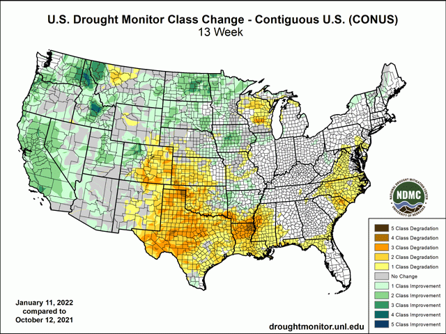
A look at drought intensity changes during the past 90 days in the contiguous United States shows a big contrast between improvement and worsening as assessed by the U.S. Drought Monitor.
The Northern Plains, Northwest, and western U.S. mostly have improvement of at least two categories of drought, with a three-category improvement in some areas. For example, central North Dakota was assessed in D3 (Extreme Drought) in mid-October; the mid-January assessment was D0 (Abnormally Dry). Farther south, it's a different story, as the Southern Plains region is generally showing a two- to three-category worsening of drought during the past 90 days, from either D0 or D1 (Moderate Drought) to generally D3 (Extreme Drought) in mid-January.
Winter dryness is a characteristic of the Southern Plains. The National Weather Service (NWS) office in Dodge City, Kansas noted that the long-term median precipitation for the winter season is only about 1 inch. Even so, the region is having a dry winter; the town of Ulysses in southwestern Kansas has received only 0.05 inch precipitation since Dec. 1, 2021, according to the Dodge City NWS record. But, for the entire Southern Plains, the start of the Water Year has been dry. The region's precipitation is from 30 to 80% below normal since Oct. 1, 2021.
P[L1] D[0x0] M[300x250] OOP[F] ADUNIT[] T[]
Meanwhile, the Northern Plains is in a much better precipitation trend. Much of the region has measured from 150-300% of normal precipitation since the start of the Water Year Oct. 1. That's a big reason why drought conditions have eased. It needs to be noted that the western one-third of the region in Montana is still dealing with the overall drier trend.
Behind this change in precipitation and drought fortunes is the influence of La Nina in the Pacific Ocean. The jet stream routing brought on by the cooler waters in the equatorial Pacific during the past six months meant a consistent storm track over the U.S. Northwest and Northern Plains. Meanwhile, the Southern Plains region has largely been out of the track of these storm systems, which compounds an already-dry trend for the winter season.
La Nina conditions appear to have peaked. Even so, the forecast through the rest of the winter and through early spring point to a continued wetter trend in the north and drier south. That is concerning for the post-dormancy period for Southern Plains winter wheat and grasses. Ahead of spring, drier soils will also be prone to additional wind damage as we have already seen in the 2021-22 meteorological winter season.
The multi-agency National Integrated Drought Information System (NIDIS) noted that "Drought ranks third among environmental phenomena associated with billion-dollar weather disasters since 1980, behind tropical cyclones and severe storms. The cost of drought events averages over $9 billion per year, making it a serious hazard with substantial socioeconomic consequences."
Bryce Anderson can be reached at Bryce.anderson@dtn.com
Follow him on Twitter @BAndersonDTN
(c) Copyright 2022 DTN, LLC. All rights reserved.


Comments
To comment, please Log In or Join our Community .