

Ag Weather Forum
Is the Rainfall in Central Brazil Good Enough?
Central Brazilian producers have been waiting for a long time, but rain has finally started to move in with a more consistent clip over the past few days and the forecast favors this to continue for a while.
Even so, the dry start to the wet season has been harmful and there are areas of the region that have yet to benefit from the increased rainfall in recent days.
An analysis of rainfall from Nov. 17-22 shows widespread rainfall occurring across most of Brazil. Rainfall amounts are estimated at 20-60 millimeters (about 0.8 to 2.4 inches) during that time. However, a close examination shows that not all areas have been hit by showers just yet. There are pockets from Mato Grosso to Minas Gerais and points northward that have yet to see the rains fall and are in dire need for that rain to begin. They cannot wait any longer as soybeans planted earlier are shriveling up and decisions need to be made regarding replanting or abandoning either the primary soybean crop, or safrinha (second-season) corn or cotton crop.
The showers have not reached everyone, but that is typical of wet season showers. Those that live in the American Southeast are familiar with similar type of pop-up showers in the summertime. They largely have a mind of their own. You can get several days in a row of very heavy rain, then get missed for long stretches and vice versa, or see fairly steady rain every or every other day for long stretches as well.
P[L1] D[0x0] M[300x250] OOP[F] ADUNIT[] T[]
But when averaged all out during a month, the amounts range from 150-250 mm (about 6-10 inches) each month during the wet season from November through March in central Brazil.
Thus, when we talk about comparisons to normal and their effect on agriculture, the numbers usually do not matter. It is the actual amount of rainfall and the frequency that is important. Half the normal amount of rainfall can be enough, as long as it comes at a fairly frequent pace to stave off any ill effects from heat.
When the rain does not fall, temperatures can be extreme. When it does not rain for long stretches, like the conditions that occurred last week, then temperatures can exceed 40 Celsius (104 Fahrenheit) on a regular basis. The combination of a lack of rain and heat can take a large toll on crops in the ground. Therefore, consistent rainfall is the bigger driver of good weather conditions for growing crops in central Brazil.
What we see in the forecast during the next week, and extending into early December, is a pattern that promotes daily showers and thunderstorms in central Brazil. Models have not been as heavy in recent runs as last week, but the showers are still there. As long as they are around, soils can start filling up and temperatures will be more moderate.
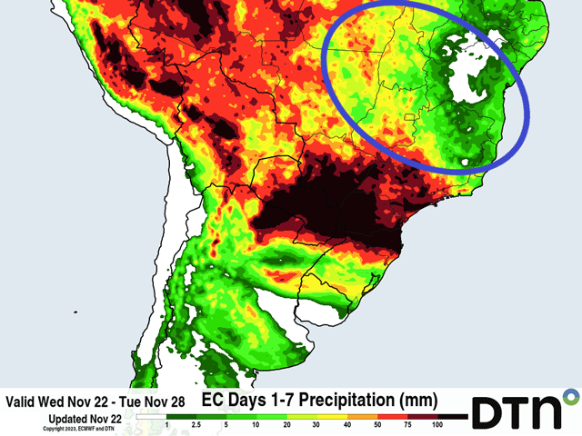
However, if they are too isolated, we could see the problems of the last few weeks becoming extended. That may be the case in some northeastern areas of Brazil. When looking at the attached image, you can see pockets of green (less than 20 mm or 0.8 inches) in sections of Mato Grosso through Minas Gerais and Tocantins and very little rainfall in the state of Bahia -- all circled.
This indicates rainfall will be too spread out and spotty during the next week in some of these areas. Farther south, forecasts are more consistent with rainfall coverage and thus the amounts as well. And, even in some of these areas farther north, the more isolated nature to the showers may not be all that bad. Plenty of areas are still going to see the rainfall they need. However, there are going to be those that do not.
Social media has been littered with videos and images from central Brazil about the heat and dryness issues affecting planting and early growth on soybeans. Unfortunately for some of the producers down there, that may still be the case during the coming week. The rain will come, it's just a matter of when, if more folks will be left out than not, and what decisions the producers there will decide to make in the coming weeks. Stay tuned.
To find more international weather conditions and your local forecast from DTN, visit https://www.dtnpf.com/….
John Baranick can be reached at john.baranick@dtn.com
(c) Copyright 2023 DTN, LLC. All rights reserved.

Comments
To comment, please Log In or Join our Community .