

Ag Weather Forum
Rain Ending, Cold Coming, Snow Falling for Thanksgiving Travel

The holiday travel season starts this week as folks gear up to prepare their houses to accept friends and family and others to do the traveling. For most of the country, there are limited issues due to the weather. But there could be some hiccups, especially for those that travel through the Rockies.
The week started with a storm system that moved from the Plains on Sunday into the Great Lakes for Tuesday. That system brought areas of moderate to heavy rain for portions of the South, Southeast, and eastern Midwest. A wintry mix of precipitation types occurred over colder spots in Michigan. The Northeast is also on the cooler side so this system will bring accumulating snow and potential for some limited freezing rain in the higher terrain Tuesday night and Wednesday. Those traveling through the coastal areas may have to deal with some weather delays due to heavy rain or wind, but not slick conditions. The Southeast could still see some severe thunderstorms out of this system as well on Tuesday.
This system clears off the coast during the day on Wednesday and most areas of the country will be quieter that day, a good time for travel. However, another cold front will be slipping into the Northern Plains and Upper Midwest and will bring some seasonably low temperatures with it. The front will continue south from Kansas to Ohio for Thanksgiving Day, bringing a nip in the air to those north of the front. The front will continue to sag southward through the holiday weekend.
P[L1] D[0x0] M[300x250] OOP[F] ADUNIT[] T[]
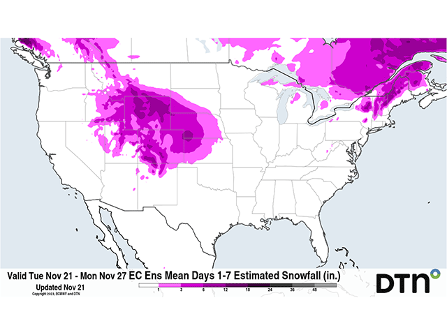
Behind that front, winds coming out of Canada will be cold, but also rising into the Rocky Mountains. When combined with a disturbance moving through the Pacific Northwest, it will produce some areas of precipitation. With cold, Canadian air below, that will largely fall as snow, starting in the Northern Rockies Wednesday night, and working southward for Thanksgiving Day. Salt Lake City and Denver may be able to hold off on the snow until Friday morning, but it will be coming there as well. Those traveling through the mountains or airports in these areas may have to deal with some nasty weather. Heavy snow is likely to fall in the Rockies and in the High Plains with varying amounts depending on location and elevation. Areas of heavy snow will be possible in the mountains and more like moderate snow (largely less than 6 inches) in the High Plains. Check your local forecast at DTN, https://www.dtnpf.com/…, for the latest snowfall totals and travel issues as they could change during the next couple of days.
On Saturday, a system is forecast to form in the precipitation in the central Rockies, moving out into the Central Plains where precipitation will continue. That could mean heavy snow away from the mountains in western and central Nebraska and Kansas, though that is uncertain at this time. This system is forecast to shift eastward into the Mississippi Valley for Sunday, but fall apart with only light and spotty showers. Still, those hanging around into the weekend across the Midwest and Mississippi Delta regions could have some weather to move through on their way home.
In addition, there is some potential for rain showers from Texas across the Gulf Coast states Thursday through the weekend as well, but showers there are likely to be spotty and not create any travel hazards. For those looking to cook outside or have a Thanksgiving football game, there could be some weather around, though.
The West Coast looks to have the quietest conditions throughout the week. Though it is a bit breezy early in the week due to Santa Ana winds in southern California, those winds are forecast to weaken on Tuesday, leaving clearer conditions for travel and festivities. The Pacific may find some limited showers Tuesday and Wednesday, but the long holiday weekend looks to be quite nice in most places.
To find more weather conditions and your local forecast from DTN, head over to https://www.dtnpf.com/….
John Baranick can be reached at john.baranick@dtn.com
(c) Copyright 2023 DTN, LLC. All rights reserved.
Comments
To comment, please Log In or Join our Community .