

Ag Weather Forum
Stormy Weather Pattern Continues Across Central US Through Mid-April
From severe thunderstorms to heavy snowfall, this spring has already proven to be active across the United States. Planting progress will steadily increase across the Southern Plains and Lower Mississippi Valley as producers get out in the fields more, but they may have to work around multiple rounds of showers and wet conditions.
As we head into mid-April, a strong low-pressure system from the West will make its way into the Plains and Midwest. Severe thunderstorms, gusty winds, widespread rainfall, and even some snow may accompany this system as it passes through the center of the country during the first half of next week.
This week's weather started off with severe thunderstorms across the Southern Plains. Parts of Northern Texas had reports of 1- to 2-inch diameter hail Monday evening along with locally strong wind gusts up to 60-70 miles per hour. Strong to severe thunderstorms and heavy rainfall will continue across parts of the southern and eastern U.S. through the rest of this week.
The Storm Prediction Center has up to a moderate risk for severe thunderstorms across Louisiana, Mississippi, and Alabama for Wednesday. With repeated rounds of storms and heavy rainfall, DTN is forecasting over 3 to 4 inches of rain across parts of Louisiana, Arkansas and Mississippi by Thursday night. Locally higher amounts up to 6 inches cannot be ruled out in some spots which could lead to areas of flooding.
P[L1] D[0x0] M[300x250] OOP[F] ADUNIT[] T[]
Precipitation across the southern U.S. will shift northeast through the second half of this week, providing rainfall and a risk for storms across the eastern Midwest. Strong to severe storms are possible across Ohio and Kentucky on Thursday. By Friday night, rainfall will approach 1 to 2 inches across Indiana and Ohio.
Producers across southern and central states are either amid planting or starting to get out in the fields. The latest USDA NASS weekly Crop Progress report released on April 8 shows that 59% of corn has been planted in Texas while states like Kansas and Missouri are just getting started. Kansas has 4% of its corn crop planted while Missouri is at 7%. Both this week's precipitation and next week's potentially strong storm system could slow down progress for some producers.
An upper-air ridge will build across the Plains and Mississippi Valley this weekend which will lead to mostly dry conditions and temperatures will also be on the rise. By Sunday afternoon, high temperatures could approach the 70s Fahrenheit across southern South Dakota and southern Minnesota. Farther south, temperatures may reach the 80s or even low 90s F in parts of the Central and Southern Plains. Mild weather like this may not last long with the pattern turning more active early next week.
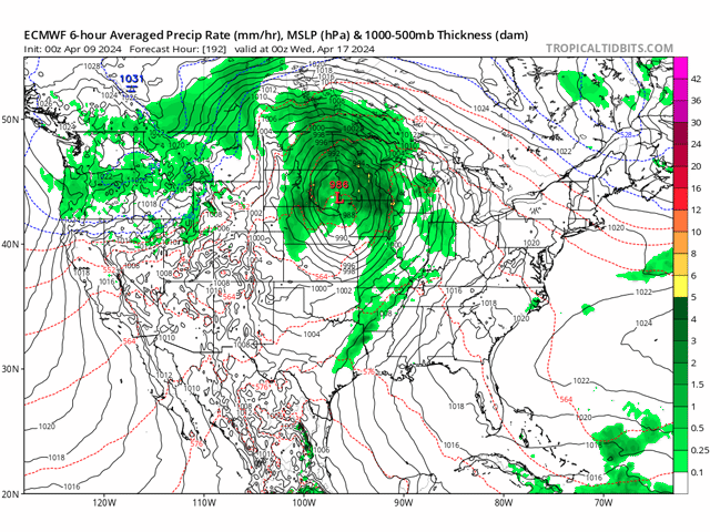
Both the American GFS model and the ECMWF (European) model show a strengthening low-pressure system from the West moving into the Plains by April 15. While this storm system is still around a week out from affecting the central U.S., both the GFS and European models have decent agreement on the track of this system. Widespread rainfall and gusty winds may accompany this system as rain showers spread across much of the Plains, Mississippi Delta, and Midwest by Tuesday. Southern areas may see another round of severe thunderstorms with this system. The Storm Prediction Center already has an area from Kansas into Texas covered in a 15% chance of severe thunderstorms for Monday. Rainfall could approach 0.5 to 1 inch across a significant portion of the Dakotas, Iowa, Minnesota, and Wisconsin by next Wednesday as well.
This upcoming system has the potential to relieve some areas of drought that exist across parts of the Upper Midwest. Parts of eastern Iowa have severe and extreme drought, and in the latest Crop Progress report, the USDA shows that 64% of Iowa's cropland is very short or short in subsoil moisture. Unlike parts of the Southern U.S. that have seen repeated rounds of rain over the past weeks, areas across the western Midwest are still in need of more precipitation ahead of spring planting.
Producers in the south may have to battle wet conditions as planting progress continues. However, farther north, the forecast calls for more precipitation in the Midwest through mid-April which should help improve soil moisture in places where there is a deficit ahead of spring planting. Lastly, as we continue through the spring, the threat of severe weather remains relevant and producers should monitor the latest weather conditions to ensure they are safe while getting out in the fields.
To find more weather conditions and your local forecast from DTN, head over to https://www.dtnpf.com/…
Teresa Wells can be reached at teresa.wells@dtn.com
(c) Copyright 2024 DTN, LLC. All rights reserved.

Comments
To comment, please Log In or Join our Community .