

Ag Weather Forum
Summer Weather Outlook as El Nino Begins Shows Variable Pattern

The recent weather pattern has been a complete flip from the La Nina-controlled past two summers. We have seen daily clusters of showers and thunderstorms up and down the Plains while the Midwest has dried out. Concern is building about dryness for crops in the middle of the country, where the dryness is leading to expanded dryness on the drought monitor with another week of below-normal rainfall forecast for these areas.
On the last day of meteorological spring, let's take a look at the weather for the summer to see if this dry pattern will continue, or if we will see any changes going forward.
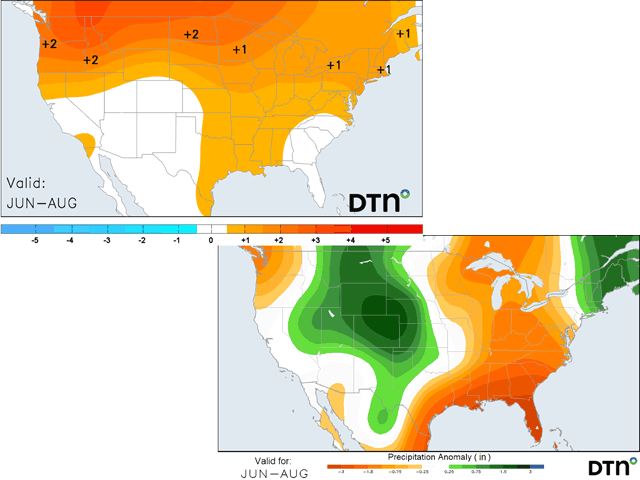
When La Nina ends and El Nino begins, such as is forecast this summer, history suggests a more variable weather pattern across much of the U.S. The base-state of El Nino produces a ridge in the West with a split jet stream across North America. The northern end brings in cold fronts and storm systems from Canada while the southern end keeps showers going along the southern tier of the country. The result is usually some lower temperatures in the Northeast and at times the Corn Belt while heat remains in the West and particularly the Pacific Northwest and Western Canada while most of North America sees a pattern that supports near-normal rainfall during the course of the season.
There are no doubt areas of winners and losers out of it where thunderstorms are more persistent or miss more often, but the general idea is for most areas to end up with near-normal amounts of rain.
Some sort of El Nino base state has already been forming in the atmosphere during May, a little earlier that would be expected given the neutrality of sea-surface temperatures in the middle of the Pacific Ocean. We are not in El Nino just yet. To see the latest update on the El Nino forecast, you can read about that here: https://www.dtnpf.com/…. But the atmosphere is trying to get to this base state while other sub-seasonal weather drivers (things like equatorial thunderstorms, blocking ridges, and the jet stream) have been weaker pattern-drivers.
P[L1] D[0x0] M[300x250] OOP[F] ADUNIT[] T[]
That El Nino base-state has resulted in the recent trend of a wetter Plains and drier Midwest during the last couple of weeks, and the forecast for the next week of roughly the same conditions. The drier pattern over the Midwest has certainly been concerning with crops just starting to emerge and develop. And the June forecast does continue this trend. While the first full week of the month continues this, models suggest a couple of fronts moving through with at least some precipitation east of the Mississippi River. The rest of June does seem to fit this overall pattern we have been in during the last two weeks (wetter Plains, drier Midwest), though not to the extreme of last week and this week.
From there, models are certainly much more variable with regards to where they put precipitation and how much, which should bring relief to some areas of the country that have been dealing with dryness. In talking with DTN Long-Range Weather Risk Analyst Nathan Hamblin, he suggested that though we have been in and will be in a drier pattern across the Midwest, that July and August are more suggestive of a more active pattern. "I think that when we get into July we should see the target area for precipitation shift northward a bit (out of the Gulf of Mexico) and into the Ohio Valley and Midwest. I can't be overly confident until we see more data on the sub-seasonal forcing, but that would be a fair assumption at this point," Hamblin said.
For clarity, Hamblin noted that models are only able to effectively forecast these subseasonal forcing factors about four weeks out and even then there is some variability in what that would mean for weather across the U.S.
So, in other words, while we have a tougher stretch of weather to go through in the Midwest, we are expecting to find some better relief when it comes to pollination and filling grain of crops in July and August. There will certainly be haves and have-nots in this pattern, but that is typical of a normal summer anyway, and nearly impossible to predict more than two weeks into the future.
Those areas in the Plains that have seen beneficial rainfall thus far appear to be on the track that would continue more widespread rainfall for the month of June, being a little more variable afterward. Drought reduction is still on the table, benefiting those areas with growing crops and pastures.
And, on the temperature side, just because it is dry in the Midwest, does not mean that it will be overly hot. This week is certainly warm, with temperatures near the 90-degree Fahrenheit mark across a lot of the Plains and Midwest. But models are insisting on readings closer to normal afterward. Rises and dips are likely to occur, and the threat for heatwaves is limited east of the Rockies.
The pattern may favor Texas with that later this summer, but the larger threat is across the Pacific Northwest. Under a more persistent ridge, higher temperatures for that region, including Western Canada and possibly into the western Canadian Prairies, are the likely result. It does not mean any records will be broken, or that heatwaves will be extreme, but the likelihood of them occurring is a greater risk this summer.
The other item of note will be in the Southwest. A winter of heavy precipitation has led to exceedingly high snowpack in the mountains, stronger streamflow, and near-elimination of long-standing drought. The El Nino base-state would be suggestive of not nearly as hot conditions, but a reduced monsoon season. Typically, those showers do not start to develop until July, though we have seen plenty of showers here going on in the Four Corners area in May. But a stronger southern jet would push more of that activity into the Plains instead of the Intermountain West, leading to lower rainfall in the region. The mountains have a lot of stored up moisture to release into rivers, but a below-average monsoon season would raise drought concerns again.
To find more weather conditions and your local forecast from DTN, head over to https://www.dtnpf.com/…
John Baranick can be reached at john.baranick@dtn.com
(c) Copyright 2023 DTN, LLC. All rights reserved.
Comments
To comment, please Log In or Join our Community .