Ag Weather Forum
Rainfall Mixed This Week in Canada's Prairies, But Continues Through Next Week
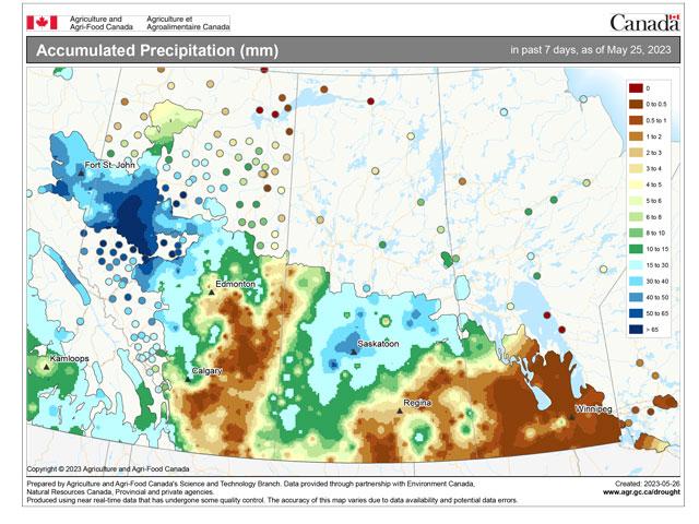
Heavier rain fell in portions of the Western Canada Prairies so far this week, but others have been left dry. Combinations of fronts, low-pressure systems, and upper-level disturbances have accounted for the wide discrepancy in the rainfall accumulation for this week.
Areas receiving over 25 millimeters (1 inch) were confined to northwestern Alberta and pockets of Saskatchewan, while many areas of Alberta and Manitoba went without a drop. Rainfall has helped to fight the wildfires in northern Alberta, but more will be needed in that regard.
As of the evening of May 26, there were 50 active wildfires in Alberta, with 14 out of control, 13 being held and 23 under control, according to the Alberta government -- already there has been 524 fires for the year, the most to date in the past five years, with 1,037,481 hectares (2,563,671 acres) burned. The province remains in a state of emergency, and there are still some special air quality statements in some places. In comparison, the next highest amount burnt in the last five years was 2018 when Alberta had 674,101 ha (1,665,739 acres) during that same time period.
P[L1] D[0x0] M[300x250] OOP[F] ADUNIT[] T[]
As for Saskatchewan, the government's most recent report as of evening May 26 showed 21 active fires, with 5 not contained, 3 contained, 3 protecting property and 10 ongoing assessment. There have been 187 fires so far this year, compared to the five-year average of 114.
With more of the region's crop now in the ground, rainfall is becoming very important to farmers and ranchers. As of the latest reports from the provinces this week (through May 26), Alberta is 85% seeded, Saskatchewan sits at 68%, and Manitoba is at 62% with significant progress over the prior week. With drought continuing to be a player in pockets across the region, rainfall needs to come at a regular clip to keep up with crop needs.
While rains have been good for some western areas earlier this week, eastern Saskatchewan and Manitoba still have some time this week to get some rains in. A weak front is pushing across these eastern areas and will allow for some showers to develop through Sunday.
Farther west, after a few dry days, showers appear to be possible starting on Sunday in Alberta and will spread out across the region through almost all of next week. Showers are forecast to be isolated, coming in smaller clusters instead of widespread areas or lines, but will be around. Also, the focus is on the western half of the region again next week, and areas of Alberta that are in deeper drought and missed out on the early week showers may be in line for some better showers over the coming week. Eastern areas have better soil moisture, but could still use some rain.
Temperatures throughout the week will be above normal, with many areas in the 20s Celsius (lower 70s to middle 80s Fahrenheit) throughout the week. While very warm, they are not high enough to cause significant stress to plants. Instead, temperatures should foster good growth for areas with adequate soil moisture. There is some concern about a couple of days that may be at the warmer end of the range next week, which may draw out more moisture from the soil, but overall, temperatures should be seen as a positive with no frosts in sight.
The forecast is still an overall favorable one for the region. Getting daily showers somewhere in the region is hard to do for two straight weeks, even if it is not at the consistency and intensity that those in the region would prefer. And temperatures will be cooperative. Now it is just a question of how widespread these showers and thunderstorms can be to those areas that are in greater need.
To find more international weather conditions and your local forecast from DTN, head over to https://www.dtnpf.com/…
John Baranick can be reached at john.baranick@dtn.com
(c) Copyright 2023 DTN, LLC. All rights reserved.


Comments
To comment, please Log In or Join our Community .