South America Calling
Argentina's Harvest Crawling Along in Wet Weather
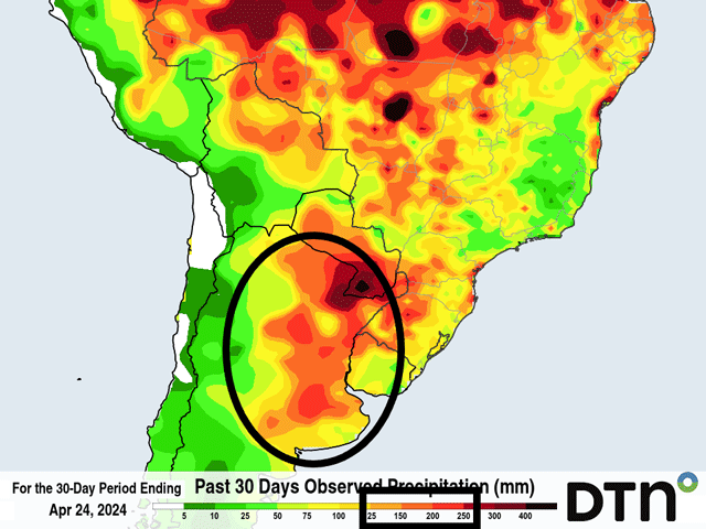
It has been awfully wet in Argentina during the last month. Many areas have seen more than 200 millimeters (about 8 inches) during the last 30 days. While the wet weather had been good for corn and soybean development, especially after a particularly hot and dry stretch in January that trimmed off the potential for a record crop, the continued wetness is leading to all sorts of issues for the crop.
Though planted a little on the later side of normal from some early dryness, the crop was met with some good rainfall through most of its development. The heatwave that occurred in January did come at an inopportune time as corn and soybeans were in the reproductive stages and early fill periods. But the rain that followed tried to make up for it.
P[L1] D[0x0] M[300x250] OOP[F] ADUNIT[] T[]
Unfortunately for producers there, it has become too heavy in many areas. According to the Buenos Aires Grain Exchange (BAGE), crop conditions have been steadily falling since the beginning of March, while moisture conditions have been stable or increasing -- an unusual combination that leads us to believe that pest and disease pressure has been weighing on crop development.
At the same time, the crop has been trying to reach maturity which has been slower due to the rain. To go along with that, the frequent rain has made it difficult for producers to go out and harvest, leaving the mature seed susceptible to disease, pests and quality issues. BAGE estimates that only 20% of the corn and 25% of the soybean crop has been harvested as of April 24. That is well-below average for this time of year. The report did not mention the actual average, but should be close to 35% for corn and 50% for soybeans.
Wet conditions continue to be a factor moving forward. A front has been waffling around northern areas throughout the week and will continue to do so through the weekend. Some showers will move through southern areas as well. Another front will push through early next week with more showers and the country stays active throughout the week with more chances of rain here or there. During the next 10 days, estimates from the European ECMWF model suggest streaks of 30 to 50 mm (about 1.2 to 2 inches) of rain across the country.
The delays will continue to mount and the production losses after a very good prospect are going to continue to slip. Private production forecasts have been trending lower due to reported diseases from leafhoppers, but they will likely continue to fall if the harvest pace cannot pick up soon.
To find more international weather conditions and your local forecast from DTN, visit https://www.dtnpf.com/….
John Baranick can be reached at john.baranick@dtn.com
(c) Copyright 2024 DTN, LLC. All rights reserved.


Comments
To comment, please Log In or Join our Community .