South America Calling
Heavy Rain Forecast for Central Brazil May Not Be Enough
Model forecasts have changed dramatically this week and are now signaling heavy rain for central Brazil and most of its safrinha (second-season) corn crop. As I wrote last week, https://www.dtnpf.com/…, soil moisture across most of Brazil's safrinha corn areas are adequate for now, but low compared to normal, and there isn't enough to last through the end of the growing season as wet season rains shut down next month.
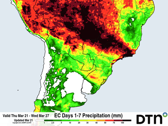
However, a change to the forecast means that there is potential to build more soil moisture over a critical area. A front that moved through Argentina Mar. 20 with some good rain is moving through southern Brazil Mar. 21. That front is forecast to move into central Brazil on Mar. 22 and remain stuck there through a good portion of next week. Models are producing more than 100 millimeters (4 inches) of soaking rainfall through Mar. 27 and keep showers going in the same area through the end of the month.
The area affected is currently forecast for most of Mato Grosso, Goias, and southern Minas Gerais, which are three of the Top 5 states for safrinha corn production, and account for about 65% of Brazil's total. The other 30-35% of production will be largely missing out, however. The states of Parana and Mato Grosso do Sul are not forecast to see much rain beyond Mar. 21 through the end of the month, putting into question how good these rains will actually be for Brazil's corn production.
P[L1] D[0x0] M[300x250] OOP[F] ADUNIT[] T[]
The other factor to consider would be if these forecasts are accurate or not. Typically, a stalled front can produce some heavy rain in an area that remains active, like what is going to happen in central Brazil at least this weekend into early next week. But can that be maintained? Experience suggests that though this front may still have some influence in the area, it will get washed out with time and not have the same potency deeper into next week than it will during the next few days. That would lead to more isolated showers with time, but models are content to keep heavy showers around through the end of the month. They may be overdoing the forecast a bit.
The primary question will be, though, how much extra soil moisture can these rains contribute to? Most of the soils affected have deficits of at least 150 mm of soil moisture according to the Climate Prediction Center maps, which you can find here: https://ipad.fas.usda.gov/…. DTN estimates that the rainfall during the last 90 days is about half of the typical amounts from Dec. 20 to Mar. 19 and there is plenty of room for soils to soak up the coming rains.
But even if realized with all rainfall soaking into the soil without runoff or use by developing corn, deficits will still exist for the safrinha crop. And deficits are likely to get larger for southern areas that do not see the rainfall.
The outlook for April is mixed with the American GFS indicating continued good rainfall over the central and north with drier conditions over the south, while the extended version of the European model has almost the exact opposite with a drier look over central and northern Brazil and wetter conditions for southern states. Neither model suggests an early end to the wet season rains though, which average May 5 for the last 30-mm rain in Mato Grosso, and is a significant turn from last week's forecast. But the lack of good moisture in the subsoils are going to be important for filling the crop out when these wet season rains shut down in about a month's time. We will be watching those estimates for subsoil moisture very carefully to see how these rains behave, and if they can fill up a significant percentage of the column or not.
To find more international weather conditions and your local forecast from DTN, visit https://www.dtnpf.com/….
John Baranick can be reached at john.baranick@dtn.com
(c) Copyright 2024 DTN, LLC. All rights reserved.


Comments
To comment, please Log In or Join our Community .